
Carte topographique Orofino
Carte interactive
Cliquez sur la carte pour afficher l’altitude.
À propos de cette carte
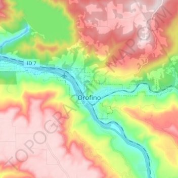
Nom : Carte topographique Orofino, altitude, relief.
Lieu : Orofino, Clearwater County, Idaho, 83544, United States (46.47097 -116.32122 46.49939 -116.19855)
Altitude moyenne : 633 m
Altitude minimum : 293 m
Altitude maximum : 964 m
The city has a climate typical of low-elevation areas in Idaho and eastern Washington. Orofino has a dry-summer continental climate (Köppen Dsb). Due to the warm summers, it nearly qualifies as a continental Mediterranean climate (Dsa). Idaho’s all-time highest temperature of 118 °F or 47.8 °C was recorded at Orofino on July 28, 1934.
Autres cartes topographiques
Cliquez sur une carte pour visualiser sa topographie, son altitude et son relief.
Clearwater County
United States > Idaho > Clearwater County
Clearwater County, Idaho, United States
Altitude moyenne : 1 250 m
Platinum Lake
United States > Idaho > Clearwater County
Platinum Lake, Clearwater County, Idaho, United States
Altitude moyenne : 1 723 m