
Carte topographique Plitvice Lakes National Park
Carte interactive
Cliquez sur la carte pour afficher l’altitude.
À propos de cette carte
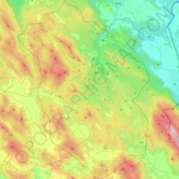
Nom : Carte topographique Plitvice Lakes National Park, altitude, relief.
Altitude moyenne : 765 m
Altitude minimum : 284 m
Altitude maximum : 1 637 m
The afforested mountain slopes serve as water reservoirs. They are also a refuge for many animal species. The large difference in altitude in a narrow space between the mountains in the south and the Korana river in the north also represents a significant criterion for biodiversity in this region. The overall difference in altitude within the national park area is 912 m (the highest elevation is Seliški vrh at 1279 m, the lowest elevation is reached at 367 m at the bridge across the Korana river).