
Carte topographique East Java
Carte interactive
Cliquez sur la carte pour afficher l’altitude.
À propos de cette carte
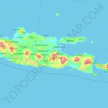
Nom : Carte topographique East Java, altitude, relief.
Lieu : East Java, Indonesia (-10.29774 109.89142 -5.09774 115.09142)
Altitude moyenne : 66 m
Altitude minimum : -1 m
Altitude maximum : 3 171 m
East Java has a tropical monsoon and savanna climate at lower elevation and subtropical at higher elevation. Compared with the western part of Java Island, East Java in general has less rainfall. Average rainfall is 1,900 mm per year, with a rainy season during the 100 days. The average temperature ranges between 19-34 °C. Temperatures in the lower mountain areas, and even in areas Ranu Pani (slopes of Mount Semeru), temperatures can reach minus 4 °C, causing a frost and fall of light snow.
Autres cartes topographiques
Cliquez sur une carte pour visualiser sa topographie, son altitude et son relief.
Sambikerep
Indonesia > East Java > Surabaya
Sambikerep, Surabaya, East Java, Indonesia
Altitude moyenne : 17 m
Cemoro Lawang
Indonesia > East Java > Cemoro Lawang
Cemoro Lawang, Probolinggo, East Java, Indonesia
Altitude moyenne : 2 171 m
Kedung Cowek
Indonesia > East Java > Surabaya
Kedung Cowek, Bulak, Surabaya, East Java, Indonesia
Altitude moyenne : 1 m
Mount Raung
Mount Raung, Bondowoso, East Java, Indonesia
Altitude moyenne : 2 808 m
Probolinggo
Indonesia > East Java > Probolinggo
Probolinggo, East Java, 62719, Indonesia
Altitude moyenne : 57 m