
Carte topographique Kelowna
Carte interactive
Cliquez sur la carte pour afficher l’altitude.
À propos de cette carte
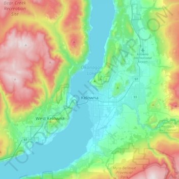
Nom : Carte topographique Kelowna, altitude, relief.
Altitude moyenne : 704 m
Altitude minimum : 335 m
Altitude maximum : 1 576 m
Kelowna is classified as a humid continental climate or an inland oceanic climate per the Köppen climate classification system due to its coldest month having an average temperature slightly above −3.0 °C (26.6 °F) and below 0 °C (32 °F),[29] with dry, hot, sunny summers and cool, cloudy winters, and four seasons.[30][31] The official climate station for Kelowna is at the Kelowna International Airport, which is at a higher elevation than the city core, with slightly higher precipitation and cooler nighttime temperatures. Kelowna has the second mildest winter of any non-coastal city in Canada, after neighbouring Penticton.[32] This is caused by the moderating effects of Okanagan Lake combined with mountains separating most of BC from the prairies; however Arctic air masses do occasionally penetrate the valley during winter, usually for very short periods. The coldest recorded temperature in the city was −36.1 °C (−33.0 °F) recorded on 30 December 1968.
Autres cartes topographiques
Cliquez sur une carte pour visualiser sa topographie, son altitude et son relief.
Lake Country
Canada > British Columbia > Regional District of Central Okanagan
Lake Country, Regional District of Central Okanagan, British Columbia, Canada
Altitude moyenne : 650 m
Okanagan Lake
Canada > British Columbia > Regional District of Central Okanagan > Kelowna
Okanagan Lake, Kelowna, Regional District of Central Okanagan, British Columbia, Canada
Altitude moyenne : 1 194 m
Moraine Park
Canada > British Columbia > Regional District of Central Okanagan > Kelowna
Moraine Park, Rutland, Kelowna, Regional District of Central Okanagan, British Columbia, Canada
Altitude moyenne : 408 m
Kangaroo
Canada > British Columbia > Regional District of Central Okanagan > East Central Okanagan Electoral Area
Kangaroo, East Central Okanagan Electoral Area, Regional District of Central Okanagan, British Columbia, Canada
Altitude moyenne : 458 m
Ellison
Canada > British Columbia > Regional District of Central Okanagan > East Central Okanagan Electoral Area > Ellison
Ellison, East Central Okanagan Electoral Area, Regional District of Central Okanagan, British Columbia, V1X 7V7, Canada
Altitude moyenne : 500 m
West Kelowna
Canada > British Columbia > Regional District of Central Okanagan > West Kelowna
West Kelowna, Regional District of Central Okanagan, British Columbia, V1Z 2T6, Canada
Altitude moyenne : 871 m