
Faire un don
Équipez-vous pour votre prochaine aventure :
En tant que Partenaire Amazon, ce site perçoit une commission sur les achats éligibles sans surcoût pour vous.
Carte topographique Lordsburg
Cliquez sur la carte pour afficher l’altitude.
Faire un don
Équipez-vous pour votre prochaine aventure :
En tant que Partenaire Amazon, ce site perçoit une commission sur les achats éligibles sans surcoût pour vous.
Lordsburg
Typical for the more southerly and lower elevations of the Intermountain West, summers are extremely hot during the daytime, with maxima above 90 °F or 32.2 °C for over four months on an average of 122 afternoons during a full year. 100 °F or 37.8 °C is exceeded on average during 30 afternoons each year, and the record high of 114 °F (45.6 °C) was set during a notorious southwestern heatwave on June 27, 1994. Humidity in early summer is very low, but increases in late summer due to the monsoon, which, between July and early October brings the majority of the year's limited precipitation. From October temperatures cool off rapidly, and by November most mornings are below 32 °F or 0 °C, but afternoons remains comfortable to warm all through the winter, with only 10.1 afternoons failing to reach 50 °F or 10 °C and only one afternoon every two years not topping freezing. Minima fall below freezing on an average of 108 mornings, but 0 °F or −17.8 °C has been reached only during two exceptional cold waves in January 1962 and December 1978, when the record low of −14 °F or −25.6 °C was reached on the 9th.
Faire un don
Équipez-vous pour votre prochaine aventure :
En tant que Partenaire Amazon, ce site perçoit une commission sur les achats éligibles sans surcoût pour vous.
À propos de cette carte
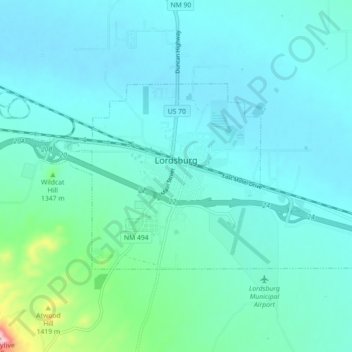
Nom : Carte topographique Lordsburg, altitude, relief.
Altitude moyenne : 1 309 m
Altitude minimum : 1 274 m
Altitude maximum : 1 545 m
Faire un don
Équipez-vous pour votre prochaine aventure :
En tant que Partenaire Amazon, ce site perçoit une commission sur les achats éligibles sans surcoût pour vous.
Autres cartes topographiques
Cliquez sur une carte pour visualiser sa topographie, son altitude et son relief.