
Carte topographique Lula
Carte interactive
Cliquez sur la carte pour afficher l’altitude.
À propos de cette carte
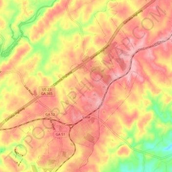
Nom : Carte topographique Lula, altitude, relief.
Lieu : Lula, Hall County, Georgia, 30554, United States (34.36506 -83.70026 34.43547 -83.64070)
Altitude moyenne : 369 m
Altitude minimum : 281 m
Altitude maximum : 418 m
Autres cartes topographiques
Cliquez sur une carte pour visualiser sa topographie, son altitude et son relief.
Gainesville
United States > Georgia > Hall County
Gainesville, Hall County, Georgia, 30501, United States
Altitude moyenne : 346 m
Clermont
United States > Georgia > Hall County
Clermont, Hall County, Georgia, United States
Altitude moyenne : 425 m
Aqualand Park
United States > Georgia > Hall County
Aqualand Park, Hall County, Georgia, United States
Altitude moyenne : 328 m
Oakwood
United States > Georgia > Hall County
Oakwood, Hall County, Georgia, United States
Altitude moyenne : 358 m
Murrayville
United States > Georgia > Hall County
Murrayville, Hall County, Georgia, 30564, United States
Altitude moyenne : 368 m
Candler
United States > Georgia > Hall County
Candler, Hall County, Georgia, 30507, United States
Altitude moyenne : 313 m
Alandale
United States > Georgia > Hall County
Alandale, Hall County, Georgia, United States
Altitude moyenne : 321 m
Bolman Estates
United States > Georgia > Hall County
Bolman Estates, Hall County, Georgia, 30507, United States
Altitude moyenne : 314 m
Hidden Acres
United States > Georgia > Hall County
Hidden Acres, Hall County, Georgia, United States
Altitude moyenne : 356 m
Lake Lanier Islands Park
United States > Georgia > Hall County
Lake Lanier Islands Park, Hall County, Georgia, United States
Altitude moyenne : 332 m
Flowery Branch
United States > Georgia > Hall County
Flowery Branch, Hall County, Georgia, 30542, United States
Altitude moyenne : 343 m
Squirrel Creek
United States > Georgia > Hall County
Squirrel Creek, Hall County, Georgia, 30506, United States
Altitude moyenne : 358 m
Green Crossing
United States > Georgia > Hall County > Buford
Green Crossing, Buford, Hall County, Georgia, United States
Altitude moyenne : 354 m
Waverly Way
United States > Georgia > Hall County
Waverly Way, Hall County, Georgia, 30566, United States
Altitude moyenne : 356 m
North Forest
United States > Georgia > Hall County > North Forest
North Forest, Hall County, Georgia, 50564, United States
Altitude moyenne : 368 m
Brookton
United States > Georgia > Hall County > Brookton
Brookton, Hall County, Georgia, 30527, United States
Altitude moyenne : 402 m