
Faire un don
Équipez-vous pour votre prochaine aventure :
En tant que Partenaire Amazon, ce site perçoit une commission sur les achats éligibles sans surcoût pour vous.
Carte topographique Schliersee
Cliquez sur la carte pour afficher l’altitude.
Faire un don
Équipez-vous pour votre prochaine aventure :
En tant que Partenaire Amazon, ce site perçoit une commission sur les achats éligibles sans surcoût pour vous.
Schliersee
Schliersee is located on the northeastern shore of the lake of the same name and is a well known resort in the Bavarian Alps. Schliersee provides scenic views of the surrounding mountains, in particular Aiplspitz, Jägerkamp (German), Brecherspitz and Bodenschneid, all belonging to the Mangfallgebirge range. The Spitzingsee area is at an elevation of 1,090 meters high and is a well known winter sports and mountain hiking centre.
Faire un don
Équipez-vous pour votre prochaine aventure :
En tant que Partenaire Amazon, ce site perçoit une commission sur les achats éligibles sans surcoût pour vous.
À propos de cette carte
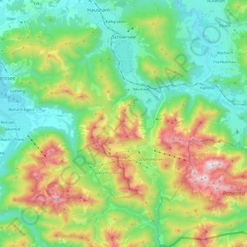
Nom : Carte topographique Schliersee, altitude, relief.
Lieu : Schliersee, Landkreis Miesbach, Bavaria, 83727, Germany (47.60823 11.79350 47.75662 11.94251)
Altitude moyenne : 1 079 m
Altitude minimum : 712 m
Altitude maximum : 1 866 m
Faire un don
Équipez-vous pour votre prochaine aventure :
En tant que Partenaire Amazon, ce site perçoit une commission sur les achats éligibles sans surcoût pour vous.
Autres cartes topographiques
Cliquez sur une carte pour visualiser sa topographie, son altitude et son relief.
Faire un don
Équipez-vous pour votre prochaine aventure :
En tant que Partenaire Amazon, ce site perçoit une commission sur les achats éligibles sans surcoût pour vous.