
Faire un don
Équipez-vous pour votre prochaine aventure :
En tant que Partenaire Amazon, ce site perçoit une commission sur les achats éligibles sans surcoût pour vous.
Carte topographique Calape
Cliquez sur la carte pour afficher l’altitude.
Faire un don
Équipez-vous pour votre prochaine aventure :
En tant que Partenaire Amazon, ce site perçoit une commission sur les achats éligibles sans surcoût pour vous.
Calape
Most of the coastal area is a fairly level plain that gradually rises into rolling hills of coralline limestone. The highest point in Calape is Mount Candungao in the eastern portion of the town, with an elevation of 150 metres (500 ft) above sea level.
Faire un don
Équipez-vous pour votre prochaine aventure :
En tant que Partenaire Amazon, ce site perçoit une commission sur les achats éligibles sans surcoût pour vous.
À propos de cette carte
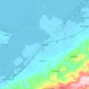
Nom : Carte topographique Calape, altitude, relief.
Lieu : Calape, Bohol, Central Visayas, 6328, Philippines (9.85051 123.83187 9.93051 123.91187)
Altitude moyenne : 46 m
Altitude minimum : -6 m
Altitude maximum : 416 m
Faire un don
Équipez-vous pour votre prochaine aventure :
En tant que Partenaire Amazon, ce site perçoit une commission sur les achats éligibles sans surcoût pour vous.
Autres cartes topographiques
Cliquez sur une carte pour visualiser sa topographie, son altitude et son relief.
Rajah Sikatuna Protected Landscape
Philippines > Bohol > San Isidro
The Rajah Sikatuna park occupies the low mountain range in the south of Bohol island which corresponds geographically with the municipalities of Carmen, Sierra Bullones, Garcia Hernandez, Valencia, Dimiao, Bilar , Loboc and Batuan. It is characterized by rolling hills with remnants of natural forest on steep…
Altitude moyenne : 349 m