
Carte topographique Norwalk
Carte interactive
Cliquez sur la carte pour afficher l’altitude.
À propos de cette carte
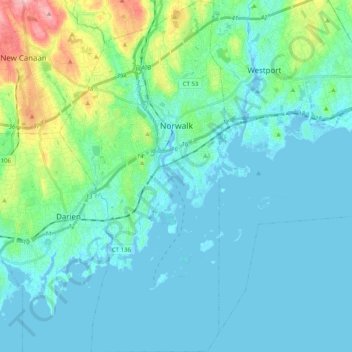
Nom : Carte topographique Norwalk, altitude, relief.
Altitude moyenne : 24 m
Altitude minimum : -7 m
Altitude maximum : 145 m
Norwalk's topography is dominated by its coastline along Long Island Sound, the Norwalk River and its eastern and western banks, and the Norwalk Islands. The highest elevation is 315 feet (96 m) above sea level on the fairway of the 16th hole of the Silvermine Golf Course, and the low elevation is sea level on Long Island Sound.
Autres cartes topographiques
Cliquez sur une carte pour visualiser sa topographie, son altitude et son relief.
Noroton
United States > Connecticut > Western Connecticut Planning Region > Darien
Noroton, Darien, Western Connecticut Planning Region, Connecticut, 06820, United States
Altitude moyenne : 18 m
Westport
United States > Connecticut > Western Connecticut Planning Region
Westport, Western Connecticut Planning Region, Connecticut, 06880, United States
Altitude moyenne : 22 m
Darien
United States > Connecticut > Western Connecticut Planning Region
Darien, Western Connecticut Planning Region, Connecticut, 06820, United States
Altitude moyenne : 12 m