
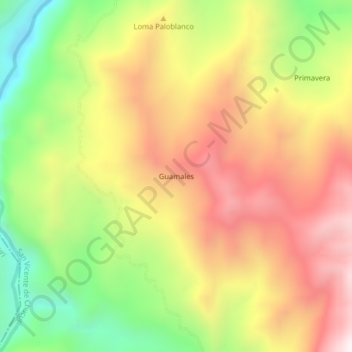
Carte topographique Guamales
Carte interactive
Cliquez sur la carte pour afficher l’altitude.
À propos de cette carte
Nom : Carte topographique Guamales, altitude, relief.
Altitude moyenne : 1 232 m
Altitude minimum : 714 m
Altitude maximum : 1 715 m
Autres cartes topographiques
Cliquez sur une carte pour visualiser sa topographie, son altitude et son relief.
La Colorada
Colombia > Santander > San Vicente de Chucurí
La Colorada, San Vicente de Chucurí, Yariguíes, Santander, RAP Gran Santander, Colombia
Altitude moyenne : 112 m
Llana Caliente
Colombia > Santander > San Vicente de Chucurí
Llana Caliente, San Vicente de Chucurí, Yariguíes, Santander, RAP Gran Santander, Colombia
Altitude moyenne : 211 m
Llana Fria - Borneo
Colombia > Santander > San Vicente de Chucurí
Llana Fria - Borneo, San Vicente de Chucurí, Yariguíes, Santander, RAP Gran Santander, Colombia
Altitude moyenne : 621 m
Brisas Del Oponcito
Colombia > Santander > San Vicente de Chucurí
Brisas Del Oponcito, San Vicente de Chucurí, Yariguíes, Santander, RAP Gran Santander, Colombia
Altitude moyenne : 347 m
Tempestuosa
Colombia > Santander > San Vicente de Chucurí > Tempestuosa
Tempestuosa, San Vicente de Chucurí, Yariguíes, Santander, Colombia
Altitude moyenne : 226 m