
Carte topographique Vårgårda kommun
Carte interactive
Cliquez sur la carte pour afficher l’altitude.
À propos de cette carte
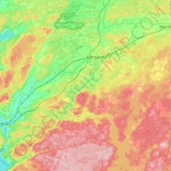
Nom : Carte topographique Vårgårda kommun, altitude, relief.
Lieu : Vårgårda kommun, Västra Götaland County, Sweden (57.85640 12.53911 58.11823 12.98585)
Altitude moyenne : 140 m
Altitude minimum : 59 m
Altitude maximum : 250 m
Autres cartes topographiques
Cliquez sur une carte pour visualiser sa topographie, son altitude et son relief.
Tibro
Sweden > Västra Götaland County
Tibro, Tibro kommun, Västra Götaland County, 543 30, Sweden
Altitude moyenne : 124 m
Kebal
Sweden > Västra Götaland County > Kebal
Kebal, Strömstads kommun, Västra Götaland County, 452 37, Sweden
Altitude moyenne : 22 m