
Carte topographique Al-Dawayah District
Carte interactive
Cliquez sur la carte pour afficher l’altitude.
À propos de cette carte
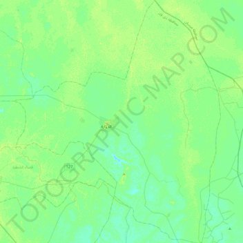
Nom : Carte topographique Al-Dawayah District, altitude, relief.
Lieu : Al-Dawayah District, Dhi Qar Governorate, 64012, Iraq (31.31659 46.21528 31.68106 46.57822)
Altitude moyenne : 8 m
Altitude minimum : 3 m
Altitude maximum : 13 m
Autres cartes topographiques
Cliquez sur une carte pour visualiser sa topographie, son altitude et son relief.
المعامل الحكومية
المعامل الحكومية, Al-Nasiriyah Central Subdistrict, Al-Nasiriyah District, Dhi Qar Governorate, Iraq
Altitude moyenne : 5 m
Al-Rifa'i District
Al-Rifa'i District, Dhi Qar Governorate, Iraq
Altitude moyenne : 9 m
Al Batha
Al Batha, Al-Batha Subdistrict, Al-Nasiriyah District, Dhi Qar Governorate, Iraq
Altitude moyenne : 8 m
Tell el-'Oueili
Iraq > Dhi Qar Governorate > Al-Rifa'i District
Tell el-'Oueili, الطريق بغداد - البصرة, Al-Nasr Subdistrict, Al-Rifa'i District, Al-Batha Subdistrict, Al-Nasiriyah District, Dhi Qar Governorate, Iraq
Altitude moyenne : 7 m
Euphrates
Iraq > Dhi Qar Governorate > Nasiriyah
Euphrates, Nasiriyah, Al-Nasiriyah Central Subdistrict, Al-Nasiriyah District, Dhi Qar Governorate, Iraq
Altitude moyenne : 6 m
Qaryat al Karush
Iraq > Dhi Qar Governorate > Qaryat al Karush
Qaryat al Karush, Al-Nasiriyah Central Subdistrict, Al-Nasiriyah District, Dhi Qar Governorate, Iraq
Altitude moyenne : 5 m
Jamaat ash Shaykh
Iraq > Dhi Qar Governorate > Harran as Sajit > Jamaat ash Shaykh
Jamaat ash Shaykh, Harran as Sajit, Al-Dawayah Central Subdistrict, Al-Dawayah District, Dhi Qar Governorate, Iraq
Altitude moyenne : 7 m
Al Kurmashiyah ash Sharqiyah
Iraq > Dhi Qar Governorate > Al Kurmashiyah ash Sharqiyah
Al Kurmashiyah ash Sharqiyah, Karmat Bani Saad Subdsitrict, Sooq Ash-Shuyookh District, Dhi Qar Governorate, Iraq
Altitude moyenne : 4 m