
Carte topographique Wyandanch
Carte interactive
Cliquez sur la carte pour afficher l’altitude.
À propos de cette carte
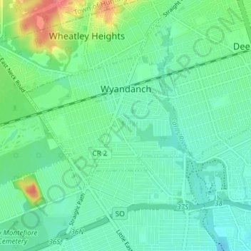
Nom : Carte topographique Wyandanch, altitude, relief.
Altitude moyenne : 21 m
Altitude minimum : 10 m
Altitude maximum : 58 m
The community was formerly known as Half Way Hollow Hills, West Deer Park (beginning in 1875), and Wyandance (in 1888). Topographically, Wyandanch's nutrient-poor loam and sandy soils are part of the outwash plain which was formed as the last glacier melted about 10,000 BCE. The outwash plain slopes gently towards Belmont Lake State Park from the Half Way Hollow Hills terminal moraine and from Little East Neck Road.
Autres cartes topographiques
Cliquez sur une carte pour visualiser sa topographie, son altitude et son relief.
North Amityville
United States > New York > Suffolk County > Town of Babylon
North Amityville, Town of Babylon, Suffolk County, New York, United States
Altitude moyenne : 15 m
Copiague
United States > New York > Suffolk County > Town of Babylon
Copiague, Town of Babylon, Suffolk County, New York, United States
Altitude moyenne : 6 m
North Lindenhurst
United States > New York > Suffolk County > Town of Babylon
North Lindenhurst, Town of Babylon, Suffolk County, New York, United States
Altitude moyenne : 14 m
Village of Lindenhurst
United States > New York > Suffolk County > Town of Babylon
Village of Lindenhurst, Town of Babylon, Suffolk County, New York, 11757, United States
Altitude moyenne : 7 m
North Babylon
United States > New York > Suffolk County > Town of Babylon
North Babylon, Town of Babylon, Suffolk County, New York, 11703, United States
Altitude moyenne : 13 m
Deer Park
United States > New York > Suffolk County > Town of Babylon
Deer Park, Town of Babylon, Suffolk County, New York, 11729, United States
Altitude moyenne : 25 m
Village of Amityville
United States > New York > Suffolk County > Town of Babylon
Village of Amityville, Town of Babylon, Suffolk County, New York, United States
Altitude moyenne : 6 m