
Carte topographique Sivas
Carte interactive
Cliquez sur la carte pour afficher l’altitude.
À propos de cette carte
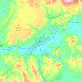
Nom : Carte topographique Sivas, altitude, relief.
Altitude moyenne : 1 455 m
Altitude minimum : 1 244 m
Altitude maximum : 2 018 m
The city, which lies at an elevation of 1,278 metres (4,193 ft) in the broad valley of the Kızılırmak river, is a moderately-sized trade center and industrial city, although the economy has traditionally been based on agriculture. Rail repair shops and a thriving manufacturing industry of rugs, bricks, cement, and cotton and woolen textiles form the mainstays of the city's economy. The surrounding region is a cereal-producing area with large deposits of iron ore which are worked at Divriği.