
Carte topographique Pallejà
Carte interactive
Cliquez sur la carte pour afficher l’altitude.
À propos de cette carte
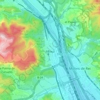
Nom : Carte topographique Pallejà, altitude, relief.
Lieu : Pallejà, Baix Llobregat, Barcelona, Catalunha, Espanha (41.40580 1.94464 41.43982 2.00939)
Altitude moyenne : 97 m
Altitude minimum : 14 m
Altitude maximum : 330 m
Autres cartes topographiques
Cliquez sur une carte pour visualiser sa topographie, son altitude et son relief.
Sant Just Desvern
Espanha > Catalunha > Baix Llobregat
Sant Just Desvern, Baix Llobregat, Barcelona, Catalunha, Espanha
Altitude moyenne : 158 m
el Prat de Llobregat
Espanha > Catalunha > Baix Llobregat > el Prat de Llobregat
el Prat de Llobregat, Baix Llobregat, Barcelona, Catalunha, 08820, Espanha
Altitude moyenne : 5 m
Sant Boi de Llobregat
Espanha > Catalunha > Baix Llobregat
Sant Boi de Llobregat, Baix Llobregat, Barcelona, Catalunha, 08830, Espanha
Altitude moyenne : 34 m