
Carte topographique Hokkaido Prefecture
Carte interactive
Cliquez sur la carte pour afficher l’altitude.
À propos de cette carte
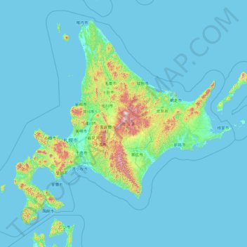
Nom : Carte topographique Hokkaido Prefecture, altitude, relief.
Lieu : Hokkaido Prefecture, Japan (41.15206 139.06728 45.71120 145.91603)
Altitude moyenne : 81 m
Altitude minimum : -3 m
Altitude maximum : 2 072 m
As Japan's coldest region, Hokkaidō has relatively cool summers and icy/snowy winters. Most of the island falls in the humid continental climate zone with Köppen climate classification Dfb (hemiboreal) in most areas but Dfa (hot summer humid continental) in some inland lowlands. The average August temperature ranges from 17 to 22 °C (62.6 to 71.6 °F), while the average January temperature ranges from −12 to −4 °C (10.4 to 24.8 °F), in both cases depending on elevation and distance from the ocean, though temperatures on the western side of the island tend to be a little warmer than on the eastern. The highest temperature ever recorded is 39.5 °C (103.1 °F) on 26 May 2019.
Autres cartes topographiques
Cliquez sur une carte pour visualiser sa topographie, son altitude et son relief.
Mount Fuji
Mount Fuji, Fujinomiya, Sunto District, Shizuoka Prefecture, Japan
Altitude moyenne : 3 261 m
Rumoi
Rumoi, Rumoi Subprefecture, Hokkaidō Prefecture, 077-0041, Japan
Altitude moyenne : 155 m
Naka District
Naka District, Kanagawa Prefecture, Japan
Altitude moyenne : 13 m
Hokkaido
Japan > Hokkaidō Region > Shintoku
Hokkaido, トノカリ2の沢支線林道, Shintoku, Kamikawa, Tokachi Subprefecture, Hokkaidō Prefecture, Hokkaidō Region, Japan
Altitude moyenne : 826 m
Minamitsuru District
Fujikawaguchiko, Minamitsuru District, Yamanashi Prefecture, Chubu Region, Japan
Altitude moyenne : 1 127 m
Shibetsu
Shibetsu, Nemuro Subprefecture, Hokkaidō Prefecture, Hokkaidō Region, 086-1632, Japan
Altitude moyenne : 105 m
Murakami
Japan > Chubu Region > Murakami
Murakami, Niigata Prefecture, Chubu Region, Japan
Altitude moyenne : 404 m
由比ガ浜3
Japan > Kanagawa Prefecture > Kamakura > 由比ガ浜3
由比ガ浜3, Kamakura, Kanagawa Prefecture, Kanto, 248-0014, Japan
Altitude moyenne : 28 m
Osaka
Japan > Kinki Region > Osaka
Kita, Osaka, Osaka Prefecture, Kinki Region, Japan
Altitude moyenne : 10 m
Honshu
Japan > Chubu Region > Ogawa
Honshu, Ogawa, Kamiminotchi County, Nagano Prefecture, Chubu Region, Japan
Altitude moyenne : 91 m
Tsushima
Tsushima, Nagasaki Prefecture, Kyushu Region, Japan
Altitude moyenne : 7 m
Yakushima
Japan > Kyushu Region > Yakushima
Yakushima, Kumage County, Kagoshima Prefecture, Kyushu Region, Japan
Altitude moyenne : 401 m
Shibuya 1-chome
Japan > Tokyo > Shibuya > Shibuya 1-chome
Shibuya 1-chome, Shibuya, Tokyo, Kanto, 1500002, Japan
Altitude moyenne : 34 m
辺野古岳
Japan > Kyushu Region > Nago
辺野古岳, Nago, Okinawa Prefecture, Kyushu Region, 905-0024, Japan
Altitude moyenne : 143 m
Ryukyu Islands
Japan > Kyushu Region > Nago
Ryukyu Islands, Green Street, Nago, Okinawa Prefecture, Kyushu Region, 905-2266, Japan
Altitude moyenne : 4 m
Mt. Tsurugi
Japan > Shikoku Region > Naka
Mt. Tsurugi, Naka, Naka County, Tokushima Prefecture, Shikoku Region, 779-4306, Japan
Altitude moyenne : 1 584 m
Kyoto Prefecture
Japan > Kinki Region > Kyotanba
Kyoto Prefecture, 綾部宮島線, Kyotanba, Funai County, Kyoto Prefecture, Kinki Region, Japan
Altitude moyenne : 453 m