
Faire un don
Équipez-vous pour votre prochaine aventure :
En tant que Partenaire Amazon, ce site perçoit une commission sur les achats éligibles sans surcoût pour vous.
Carte topographique Gioia del Colle
Cliquez sur la carte pour afficher l’altitude.
Faire un don
Équipez-vous pour votre prochaine aventure :
En tant que Partenaire Amazon, ce site perçoit une commission sur les achats éligibles sans surcoût pour vous.
Gioia del Colle
Gioia del Colle is on the top of a hill at 360 m a.s.l. It is located in the southern part of the Murge, in the "Sella di Gioia del Colle". It is between the North-West Murge and the South-West Murge and the Adriatic Sea and the Ionian Sea. The municipal area has an area of 206.48 km2 and it reaches a maximum altitude of 435 m a.s.l. and a minimum of 296 m a.s.l. Its area borders to the North-West with Acquaviva delle Fonti, to the North with Sammichele di Bari, to the North-East with Turi, to the East with Putignano and Noci, to the South-East with Mottola, to the South with Castellaneta, to the South-West with Laterza and to the West with Santeramo in Colle.
Faire un don
Équipez-vous pour votre prochaine aventure :
En tant que Partenaire Amazon, ce site perçoit une commission sur les achats éligibles sans surcoût pour vous.
À propos de cette carte
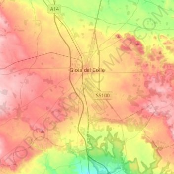
Nom : Carte topographique Gioia del Colle, altitude, relief.
Lieu : Gioia del Colle, Bari, Apulia, 70023, Italy (40.69298 16.78760 40.86271 17.03540)
Altitude moyenne : 351 m
Altitude minimum : 242 m
Altitude maximum : 440 m
Faire un don
Équipez-vous pour votre prochaine aventure :
En tant que Partenaire Amazon, ce site perçoit une commission sur les achats éligibles sans surcoût pour vous.
Autres cartes topographiques
Cliquez sur une carte pour visualiser sa topographie, son altitude et son relief.