
Carte topographique Winnipeg
Carte interactive
Cliquez sur la carte pour afficher l’altitude.
À propos de cette carte
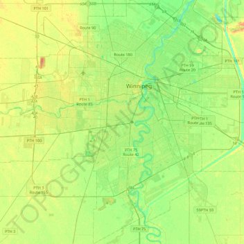
Nom : Carte topographique Winnipeg, altitude, relief.
Lieu : Winnipeg, Division No. 11, Manitoba, Canada (49.71355 -97.34915 49.99401 -96.95653)
Altitude moyenne : 236 m
Altitude minimum : 222 m
Altitude maximum : 261 m
Winnipeg lies at the bottom of the Red River Valley, a flood plain with an extremely flat topography. It is on the eastern edge of the Canadian Prairies in Western Canada and is known as the "Gateway to the West". Winnipeg is bordered by tallgrass prairie to the west and south and the aspen parkland to the northeast, although most of the native prairie grasses have been removed for agriculture and urbanization. It is relatively close to many large Canadian Shield lakes and parks, as well as Lake Winnipeg (the Earth's 11th largest freshwater lake). Winnipeg has North America's largest extant mature urban elm forest. The city has an area of 464.08 km2 (179.18 sq mi).
Autres cartes topographiques
Cliquez sur une carte pour visualiser sa topographie, son altitude et son relief.
Raleigh Park
Canada > Manitoba > Division No. 11 > Winnipeg
Raleigh Park, Rossmere–A, North Kildonan, Winnipeg, Division No. 11, Manitoba, Canada
Altitude moyenne : 232 m