
Carte topographique Palatine Hill
Carte interactive
Cliquez sur la carte pour afficher l’altitude.
À propos de cette carte
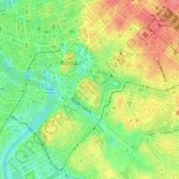
Nom : Carte topographique Palatine Hill, altitude, relief.
Lieu : Palatine Hill, Rome, RM, Lazio, 00184, Italy (41.87931 12.47711 41.89931 12.49711)
Altitude moyenne : 40 m
Altitude minimum : 3 m
Altitude maximum : 79 m
Autres cartes topographiques
Cliquez sur une carte pour visualiser sa topographie, son altitude et son relief.
Municipio Roma XII
Municipio Roma XII, Rome, RM, Lazio, Italy
Altitude moyenne : 45 m
Municipio Roma VII
Municipio Roma VII, Rome, RM, Lazio, Italy
Altitude moyenne : 83 m