
Faire un don
Équipez-vous pour votre prochaine aventure :
En tant que Partenaire Amazon, ce site perçoit une commission sur les achats éligibles sans surcoût pour vous.
Carte topographique Mount Pangasun
Cliquez sur la carte pour afficher l’altitude.
Faire un don
Équipez-vous pour votre prochaine aventure :
En tant que Partenaire Amazon, ce site perçoit une commission sur les achats éligibles sans surcoût pour vous.
Mount Pangasun
Babuyan Claro is a stratovolcano with an elevation of 843 meters (2,766 ft) and a base diameter of about 8 kilometers (5.0 mi) located in the center of Babuyan Island (also referred to as Babuyan Claro Island). It has four morphologically-fresh volcanic edifices: Mt. Cayonan in the south, Mt. Naydi and Mt. Dionisio in the southeast. Babuyan Claro has two very well-preserved craters 300 and 400 meters (980 and 1,310 ft) in diameter.
Faire un don
Équipez-vous pour votre prochaine aventure :
En tant que Partenaire Amazon, ce site perçoit une commission sur les achats éligibles sans surcoût pour vous.
À propos de cette carte
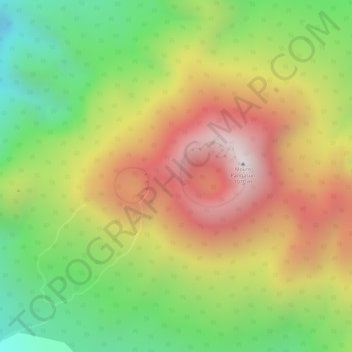
Nom : Carte topographique Mount Pangasun, altitude, relief.
Altitude moyenne : 688 m
Altitude minimum : 380 m
Altitude maximum : 1 061 m
Faire un don
Équipez-vous pour votre prochaine aventure :
En tant que Partenaire Amazon, ce site perçoit une commission sur les achats éligibles sans surcoût pour vous.
Autres cartes topographiques
Cliquez sur une carte pour visualiser sa topographie, son altitude et son relief.