
Carte topographique Lusaka
Carte interactive
Cliquez sur la carte pour afficher l’altitude.
À propos de cette carte
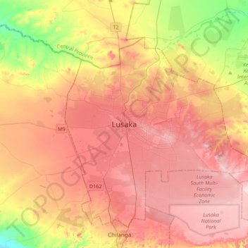
Nom : Carte topographique Lusaka, altitude, relief.
Lieu : Lusaka, Lusaka District, Lusaka Province, 10101, Zambia (-15.57634 28.12184 -15.25634 28.44184)
Altitude moyenne : 1 227 m
Altitude minimum : 1 064 m
Altitude maximum : 1 349 m
Lusaka (/luːˈsɑːkə/; loo-SAH-kə) is the capital and largest city of Zambia. It is one of the fastest-developing cities in southern Africa. Lusaka is in the southern part of the central plateau at an elevation of about 1,279 metres (4,196 ft). As of 2019, the city's population was about 3.3 million, while the urban population is estimated at 2.5 million in 2018. Lusaka is the centre of both commerce and government in Zambia and connects to the country's four main highways heading north, south, east and west. English is the official language of the city administration, while Bemba, Tonga, Lenje, Soli, Lozi and Nyanja are the commonly spoken street languages.
Autres cartes topographiques
Cliquez sur une carte pour visualiser sa topographie, son altitude et son relief.
Kafue
Kafue, Kafue District, Lusaka Province, Zambia
Altitude moyenne : 1 028 m