
Carte topographique Dorf an der Pram
Carte interactive
Cliquez sur la carte pour afficher l’altitude.
À propos de cette carte
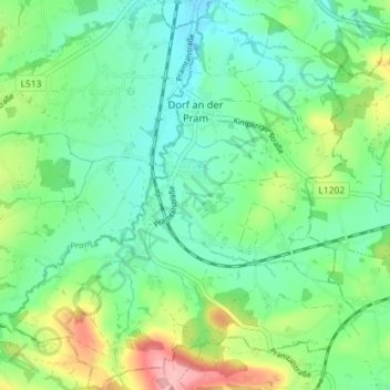
Nom : Carte topographique Dorf an der Pram, altitude, relief.
Lieu : Dorf an der Pram, Bezirk Schärding, 4751, Österreich (48.24532 13.59039 48.29304 13.65682)
Altitude moyenne : 412 m
Altitude minimum : 374 m
Altitude maximum : 500 m
Dorf an der Pram liegt auf 395 m Höhe im Innviertel. Die Ausdehnung beträgt von Nord nach Süd 4,9 km, von West nach Ost 5,3 km. Die Gesamtfläche beträgt 12,6 km². 7,9 % der Fläche sind bewaldet, 80,2 % der Fläche sind landwirtschaftlich genutzt.