
Carte topographique Heide
Carte interactive
Cliquez sur la carte pour afficher l’altitude.
À propos de cette carte
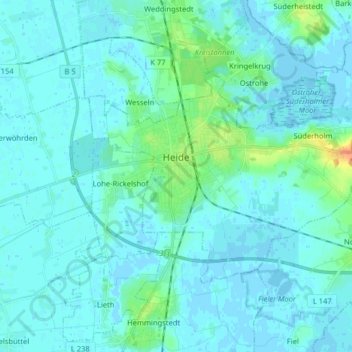
Nom : Carte topographique Heide, altitude, relief.
Lieu : Heide, Dithmarschen, Sleeswijk-Holstein, 25746, Duitsland (54.16103 9.05261 54.21828 9.21301)
Altitude moyenne : 5 m
Altitude minimum : -3 m
Altitude maximum : 35 m
Autres cartes topographiques
Cliquez sur une carte pour visualiser sa topographie, son altitude et son relief.
Wallen
Duitsland > Sleeswijk-Holstein > Dithmarschen
Wallen, Eider, Dithmarschen, Sleeswijk-Holstein, Duitsland
Altitude moyenne : 1 m
Kleve
Duitsland > Sleeswijk-Holstein > Dithmarschen
Kleve, Eider, Dithmarschen, Sleeswijk-Holstein, Duitsland
Altitude moyenne : 1 m