
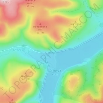
Carte topographique Cappercleuch
Carte interactive
Cliquez sur la carte pour afficher l’altitude.
À propos de cette carte
Nom : Carte topographique Cappercleuch, altitude, relief.
Altitude moyenne : 378 m
Altitude minimum : 245 m
Altitude maximum : 618 m
Autres cartes topographiques
Cliquez sur une carte pour visualiser sa topographie, son altitude et son relief.
Stow
United Kingdom > Scotland > Scottish Borders
Stow, Scottish Borders, Scotland, TD1 2RE, United Kingdom
Altitude moyenne : 268 m
Blacklaw
United Kingdom > Scotland > Scottish Borders
Blacklaw, Scottish Borders, Scotland, ML12 6QR, United Kingdom
Altitude moyenne : 360 m
Abbey St. Bathans
United Kingdom > Scotland > Scottish Borders
Abbey St. Bathans, Scottish Borders, Scotland, TD11 3TX, United Kingdom
Altitude moyenne : 212 m
West Linton
United Kingdom > Scotland > Scottish Borders
West Linton, Scottish Borders, Scotland, EH46 7ED, United Kingdom
Altitude moyenne : 264 m
Roberton
United Kingdom > Scotland > Scottish Borders > Roberton
Roberton, Scottish Borders, Scotland, TD9 7LX, United Kingdom
Altitude moyenne : 244 m
Kelso
United Kingdom > Scotland > Scottish Borders
Kelso, Scottish Borders, Scotland, TD5 7HG, United Kingdom
Altitude moyenne : 79 m