
Carte topographique Samarina
Carte interactive
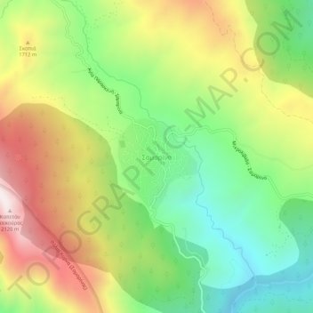
Cliquez sur la carte pour afficher l’altitude.
À propos de cette carte
Nom : Carte topographique Samarina, altitude, relief.
Altitude moyenne : 1 558 m
Altitude minimum : 1 158 m
Altitude maximum : 2 092 m
Samarina is located on an eastern spur of Mount Smolikas, the highest of the Pindus range and the second-highest mountain in all of Greece. At an altitude of 1380–1515 meters (4528' to 4970'), it is considered one of the highest villages in Greece and also one of the highest in the Balkans; its height puts it among soaring settlements such as: Aetomilitsa (Densko) and Seli (Selia).
Autres cartes topographiques
Cliquez sur une carte pour visualiser sa topographie, son altitude et son relief.
Δεσκάτη
Greece > Epirus and Western Macedonia > Grevena Regional Unit > Deskati Municipal Unit
Δεσκάτη, Deskati Municipal Unit, Deskati Municipality, Grevena Regional Unit, Western Macedonia, Epirus and Western Macedonia, 512 00, Greece
Altitude moyenne : 952 m
Βατόλακκος
Greece > Epirus and Western Macedonia > Grevena Regional Unit
Βατόλακκος, Municipality of Grevena, Grevena Regional Unit, Western Macedonia, Epirus and Western Macedonia, 511 00, Greece
Altitude moyenne : 584 m