
Carte topographique Wisconsin River
Carte interactive
Cliquez sur la carte pour afficher l’altitude.
À propos de cette carte
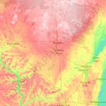
Nom : Carte topographique Wisconsin River, altitude, relief.
Lieu : Wisconsin River, Wood County, Wisconsin, 54519, USA (42.98836 -91.15680 46.15201 -89.04941)
Altitude moyenne : 333 m
Altitude minimum : 172 m
Altitude maximum : 576 m
Autres cartes topographiques
Cliquez sur une carte pour visualiser sa topographie, son altitude et son relief.
Milwaukee River
Milwaukee River, Glendale, Milwaukee County, Wisconsin, 53209, USA
Altitude moyenne : 196 m
Lake Mendota
Lake Mendota, Memorial Drive, North Side, Madison, Dane County, Wisconsin, 53704, USA
Altitude moyenne : 265 m
Fish Creek
Fish Creek, Town of Menominee, Menominee County, Wisconsin, USA
Altitude moyenne : 322 m
Peshtigo River
Peshtigo River, Town of Peshtigo, Marinette County, Wisconsin, USA
Altitude moyenne : 176 m
Apostle Islands National Lakeshore
Apostle Islands National Lakeshore, Ashland County, Wisconsin, USA
Altitude moyenne : 189 m
Lake Wissota
USA > Wisconsin > Lake Wissota
Lake Wissota, Town of Lafayette, Chippewa County, Wisconsin, USA
Altitude moyenne : 281 m
Heckrodt Wetland Reserve
Heckrodt Wetland Reserve, Friendship Trail, Menasha, Winnebago County, Wisconsin, 54952, USA
Altitude moyenne : 231 m
WEVR-AM (River Falls)
WEVR-AM (River Falls), Radio Road, Glover, Town of Troy, Saint Croix County, Wisconsin, 54022, USA
Altitude moyenne : 301 m
Sherwood Glen
USA > Wisconsin > Town of Burke > Sherwood Glen
Sherwood Glen, Town of Burke, Dane County, Wisconsin, 53783, USA
Altitude moyenne : 288 m
Historic Third Ward
Historic Third Ward, Milwaukee, Milwaukee County, Wisconsin, USA
Altitude moyenne : 182 m
Governor Knowles State Forest
USA > Wisconsin > Grantsburg
Governor Knowles State Forest, County Road F, Grantsburg, Town of Grantsburg, Burnett County, Wisconsin, 54840, USA
Altitude moyenne : 302 m
Randall Creek
Randall Creek, Town of Frankfort, Marathon County, Wisconsin, USA
Altitude moyenne : 418 m
Virgin Lake
Virgin Lake, Roby Road, Pleasant Hill, Stoughton, Dane County, Wisconsin, 53589, USA
Altitude moyenne : 280 m
Fall Creek
Fall Creek, Town of Lima, Pepin County, Wisconsin, USA
Altitude moyenne : 271 m
McGee Creek
McGee Creek, Town of Evergreen, Langlade County, Wisconsin, 54430, USA
Altitude moyenne : 410 m
Kemp Natural Resources Station
Kemp Natural Resources Station, 9161, Kemp Road, Town of Woodruff, Oneida County, Wisconsin, 54568, USA
Altitude moyenne : 491 m
Mequon Nature Preserve
Mequon Nature Preserve, Swan Road Loop, Huntington Park, Mequon, Ozaukee County, Wisconsin, 53097, USA
Altitude moyenne : 223 m
Two Creeks Buried Forest State Natural Area
Two Creeks Buried Forest State Natural Area, State Highway 42, Birchwood, Kewaunee County, Wisconsin, 54216, USA
Altitude moyenne : 187 m
Mud Lake Bog State Natural Area
Mud Lake Bog State Natural Area, Town of Wyoming, Waupaca County, Wisconsin, USA
Altitude moyenne : 312 m
Goose Lake
Goose Lake, Prairie Lane, Town of Arlington, Columbia County, Wisconsin, 53911, USA
Altitude moyenne : 314 m
Rush River Delta State Natural Area
USA > Wisconsin > Warrentown
Rush River Delta State Natural Area, Warrentown, Pierce County, Wisconsin, 55026, USA
Altitude moyenne : 227 m
Parfreys Glen Creek
Parfreys Glen Creek, Town of Merrimac, Sauk County, Wisconsin, 53561, USA
Altitude moyenne : 295 m
Raspberry Island
Raspberry Island, Town of Russell, Bayfield County, Wisconsin, USA
Altitude moyenne : 182 m
Hawthorn Hollow Nature Center
USA > Wisconsin > Village of Somers
Hawthorn Hollow Nature Center, Village of Somers, Kenosha County, Wisconsin, USA
Altitude moyenne : 207 m
Havenwoods
Havenwoods, Milwaukee, Milwaukee County, Wisconsin, USA
Altitude moyenne : 211 m
Point Beach State Forest
Point Beach State Forest, Sandy Bay Road, Manitowoc County, Wisconsin, 54241-3022, USA
Altitude moyenne : 181 m
Split Rock Creek
Split Rock Creek, Town of Fairbanks, Shawano County, Wisconsin, 54486, USA
Altitude moyenne : 302 m
Brady Street
Brady Street, Milwaukee, Milwaukee County, Wisconsin, USA
Altitude moyenne : 194 m
Silver Spring
Silver Spring, Milwaukee, Milwaukee County, Wisconsin, USA
Altitude moyenne : 219 m
Monson Lake
Monson Lake, North Refuge Road, Town of West Marshland, Burnett County, Wisconsin, 54840, USA
Altitude moyenne : 288 m
Retzer Nature Center
USA > Wisconsin > Waukesha > Town of Delafield
Retzer Nature Center, S14 W2817, Madison Street, Waukesha, Town of Delafield, Waukesha County, Wisconsin, 53188, USA
Altitude moyenne : 269 m
Washington Park
Washington Park, Milwaukee, Milwaukee County, Wisconsin, USA
Altitude moyenne : 215 m
Token Creek County Park
USA > Wisconsin > Town of Burke > Token Creek
Token Creek County Park, 6200, Token Creek, Town of Burke, Dane County, Wisconsin, 53532, USA
Altitude moyenne : 275 m
Hunter Island
USA > Wisconsin > Wisconsin Rapids
Hunter Island, Wisconsin Rapids, Wood County, Wisconsin, 54494, USA
Altitude moyenne : 330 m
Brentwood Village
Brentwood Village, Madison, Dane County, Wisconsin, USA
Altitude moyenne : 268 m
Upper East Side
Upper East Side, Milwaukee, Milwaukee County, Wisconsin, USA
Altitude moyenne : 197 m
Dunnville Barrens State Natural Area
Dunnville Barrens State Natural Area, 580th Street, Dunnville, Dunn County, Wisconsin, USA
Altitude moyenne : 230 m
Gordon Bubolz Nature Preserve
USA > Wisconsin > Grand Chute
Gordon Bubolz Nature Preserve, 4815, North Lynndale Drive, Grand Chute, Town of Grand Chute, Outagamie County, Wisconsin, 54913, USA
Altitude moyenne : 248 m
Lake Kegonsa
USA > Wisconsin > Petty Acres
Lake Kegonsa, Williams Point Drive, Petty Acres, Dane County, Wisconsin, 53589, USA
Altitude moyenne : 260 m
Riverside Park
Riverside Park, Milwaukee, Milwaukee County, Wisconsin, USA
Altitude moyenne : 201 m