
Carte topographique Acerno
Carte interactive
Cliquez sur la carte pour afficher l’altitude.
À propos de cette carte
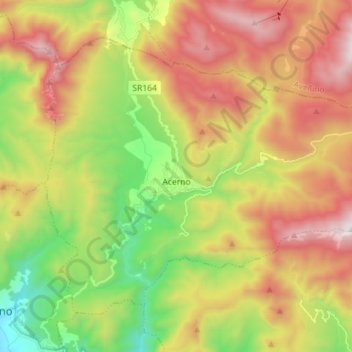
Nom : Carte topographique Acerno, altitude, relief.
Lieu : Acerno, Salerno, Campania, 84042, Italy (40.69710 15.00360 40.78177 15.14572)
Altitude moyenne : 954 m
Altitude minimum : 241 m
Altitude maximum : 1 778 m
The communal territory has an elevation varying between 400 and 1790 metres above sea level. Outside of the town itself it is entirely uninhabited by humans: there are no satellite hamlets or even scattered dwellings under permanent habitation. It is rich in flora, however, with forests of maple, oak, chestnut, hazel, beech and alder, while the fauna includes golden eagles, dormice, wild cats, otters and wolves.
Autres cartes topographiques
Cliquez sur une carte pour visualiser sa topographie, son altitude et son relief.
Altavilla Silentina
Altavilla Silentina, Salerno, Campania, 84045, Italy
Altitude moyenne : 119 m
Il Gallo Lungo
Italy > Campania > Salerno > Positano
Il Gallo Lungo, Positano, Salerno, Campania, Italy
Altitude moyenne : 0 m
Valico di Chiunzi
Valico di Chiunzi, Tramonti, Salerno, Campania, 84016, Italy
Altitude moyenne : 512 m
Nocera Inferiore
Nocera Inferiore, Salerno, Campania, 84014, Italy
Altitude moyenne : 155 m
Paestum
Italy > Campania > Salerno > Capaccio Paestum
Paestum, Capaccio Paestum, Salerno, Campania, 84047, Italy
Altitude moyenne : 12 m
Castelcivita
Italy > Campania > Salerno > Castelcivita
Castelcivita, Salerno, Campania, 84020, Italy
Altitude moyenne : 603 m
Vallo della Lucania
Vallo della Lucania, Salerno, Campania, Italy
Altitude moyenne : 510 m