
Carte topographique Waimate
Carte interactive
Cliquez sur la carte pour afficher l’altitude.
À propos de cette carte
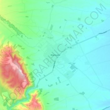
Nom : Carte topographique Waimate, altitude, relief.
Lieu : Waimate, Waimate District, Canterbury, 7924, New Zealand (-44.77388 171.00234 -44.69388 171.08234)
Altitude moyenne : 100 m
Altitude minimum : 17 m
Altitude maximum : 408 m
Autres cartes topographiques
Cliquez sur une carte pour visualiser sa topographie, son altitude et son relief.
Morven
New Zealand > Canterbury > Waimate District
Morven, Waimate District, Canterbury, New Zealand
Altitude moyenne : 22 m
Glenavy
New Zealand > Canterbury > Waimate District
Glenavy, Waimate District, Canterbury, 7980, New Zealand
Altitude moyenne : 23 m
Esk Valley
New Zealand > Canterbury > Waimate District
Esk Valley, Waimate District, Canterbury, New Zealand
Altitude moyenne : 93 m
Waitaki River
New Zealand > Canterbury > Waimate District > Glenavy
Waitaki River, Glenavy, Waimate District, Canterbury, New Zealand
Altitude moyenne : 19 m