
Carte topographique Bayog
Carte interactive
Cliquez sur la carte pour afficher l’altitude.
Bayog
The town is partly situated in the Sibougey Valley watered by the Sibuguey River, Dipili River, and Depore River. 75% of the land lies on rugged terrain with elevation up to 300 metres (980 ft).
À propos de cette carte
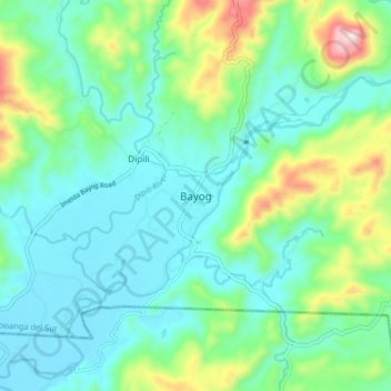
Nom : Carte topographique Bayog, altitude, relief.
Altitude moyenne : 137 m
Altitude minimum : 26 m
Altitude maximum : 485 m
Autres cartes topographiques
Cliquez sur une carte pour visualiser sa topographie, son altitude et son relief.