
Carte topographique Town of Albany
Carte interactive
Cliquez sur la carte pour afficher l’altitude.
À propos de cette carte
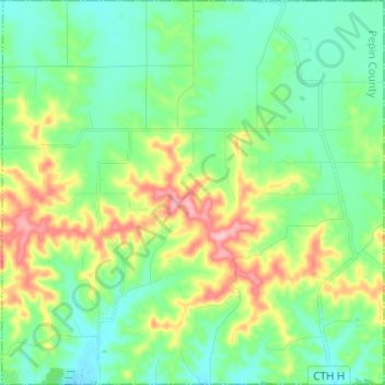
Nom : Carte topographique Town of Albany, altitude, relief.
Altitude moyenne : 298 m
Altitude minimum : 255 m
Altitude maximum : 397 m
Autres cartes topographiques
Cliquez sur une carte pour visualiser sa topographie, son altitude et son relief.
Prospect Creek
United States of America > Wisconsin
Prospect Creek, Town of Hewitt, Marathon County, Wisconsin, United States of America
Altitude moyenne : 433 m
City of Middleton
United States of America > Wisconsin > City of Middleton
City of Middleton, Dane County, Wisconsin, 53562, United States of America
Altitude moyenne : 290 m
Alderly Mill 1866c-71 Dam
United States of America > Wisconsin
Alderly Mill 1866c-71 Dam, Town of Ashippun, Dodge County, Wisconsin, United States of America
Altitude moyenne : 296 m
Big Bend
United States of America > Wisconsin > Big Bend
Big Bend, Waukesha County, Wisconsin, 53103, United States of America
Altitude moyenne : 268 m
Wills
United States of America > Wisconsin > Wills
Wills, Town of Hughes, Wisconsin, United States of America
Altitude moyenne : 359 m