
Carte topographique Lincang
Carte interactive
Cliquez sur la carte pour afficher l’altitude.
À propos de cette carte
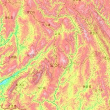
Nom : Carte topographique Lincang, altitude, relief.
Lieu : Lincang, Yunnan, 665000, China (23.07996 98.67215 25.03572 100.54641)
Altitude moyenne : 1 647 m
Altitude minimum : 479 m
Altitude maximum : 3 464 m
Lincang covers latitude 23° 05′-25° 02′ N and longitude 98° 40′-100° 33′ E, thus straddling the Tropic of Cancer in the southern part of its administrative area, or prefecture. It is situated on the middle to lower reaches of the Mekong, known as the Lancang in China, and the Salween, or the Nu. Bordering prefectures are Pu'er to the southeast, and Baoshan and Dali to the northwest. It also borders Burma's Shan State. Elevations within the prefecture range from 450 to 3,504 metres (1,476 to 11,496 ft).
Autres cartes topographiques
Cliquez sur une carte pour visualiser sa topographie, son altitude et son relief.
Gengma Dai and Va Autonomous County
Gengma Dai and Va Autonomous County, Lincang, Yunnan, 665000, China
Altitude moyenne : 1 556 m