
Carte topographique Gatton
Carte interactive
Cliquez sur la carte pour afficher l’altitude.
À propos de cette carte
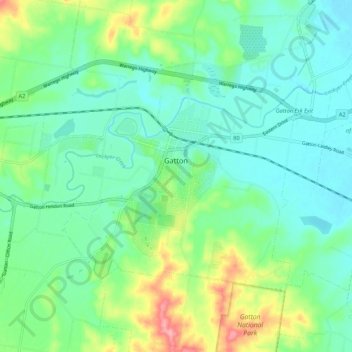
Nom : Carte topographique Gatton, altitude, relief.
Lieu : Gatton, Lockyer Valley Regional, Queensland, Australia (-27.59661 152.21943 -27.53495 152.32628)
Altitude moyenne : 118 m
Altitude minimum : 86 m
Altitude maximum : 203 m
The area has a humid subtropical climate, with hot, humid summers and mild, sunny winters, albeit with cool nights. Heavy summer rain and warm conditions have provided ideal conditions for the areas agricultural productivity, although droughts and heatwaves can be problematic at times. Temperatures in Gatton are among the warmest in south-east Queensland in summer due to its position away from the coast but at low elevation in the Brisbane Valley.
Autres cartes topographiques
Cliquez sur une carte pour visualiser sa topographie, son altitude et son relief.