
Carte topographique Hudson County
Carte interactive
Cliquez sur la carte pour afficher l’altitude.
À propos de cette carte
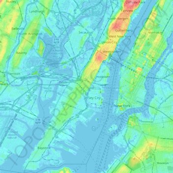
Nom : Carte topographique Hudson County, altitude, relief.
Lieu : Hudson County, New Jersey, United States of America (40.64215 -74.16609 40.82357 -73.98488)
Altitude moyenne : 12 m
Altitude minimum : -9 m
Altitude maximum : 98 m
The topography is marked by the New Jersey Palisades in the north with cliffs overlooking the Hudson to the east and less severe cuesta, or slope, to the west. They gradually level off to the southern peninsula, which is coastal and flat. The western region, around the Hackensack and Passaic is part of the New Jersey Meadowlands. Much of the land along the county's extensive shoreline and littoral zone was created by land reclamation.
Autres cartes topographiques
Cliquez sur une carte pour visualiser sa topographie, son altitude et son relief.
Mercer County
United States of America > New Jersey
Mercer County, New Jersey, United States of America
Altitude moyenne : 43 m
Ridgewood
United States of America > New Jersey > Ridgewood
Ridgewood, Bergen County, New Jersey, United States of America
Altitude moyenne : 51 m
Ho-Ho-Kus
United States of America > New Jersey > Ho-Ho-Kus
Ho-Ho-Kus, Bergen County, New Jersey, United States of America
Altitude moyenne : 58 m
Ocean County
United States of America > New Jersey
Ocean County, New Jersey, United States of America
Altitude moyenne : 15 m
Passaic County
United States of America > New Jersey
Passaic County, New Jersey, United States of America
Altitude moyenne : 182 m
Trenton
United States of America > New Jersey > Trenton
Trenton, Mercer County, New Jersey, United States of America
Altitude moyenne : 19 m