
Carte topographique Harrison County
Carte interactive
Cliquez sur la carte pour afficher l’altitude.
À propos de cette carte
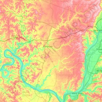
Nom : Carte topographique Harrison County, altitude, relief.
Lieu : Harrison County, Indiana, USA (37.95869 -86.33109 38.42240 -85.89986)
Altitude moyenne : 205 m
Altitude minimum : 115 m
Altitude maximum : 308 m
Autres cartes topographiques
Cliquez sur une carte pour visualiser sa topographie, son altitude et son relief.
Brown’s Ridge
USA > Indiana > Beverly Shores
Brown’s Ridge, Beverly Shores, Porter County, Indiana, 46301, USA
Altitude moyenne : 183 m
New Frankfort
USA > Indiana > New Frankfort
New Frankfort, Scott County, Indiana, 74710, USA
Altitude moyenne : 190 m
Huntington
USA > Indiana > Huntington
Huntington, Huntington County, Indiana, 46750, USA
Altitude moyenne : 238 m
Mound Haven
USA > Indiana > Mound Haven
Mound Haven, Franklin County, Indiana, 47012, USA
Altitude moyenne : 231 m
Woodville Hills
USA > Indiana > Woodville Hills
Woodville Hills, Monroe County, Indiana, USA
Altitude moyenne : 196 m