
Carte topographique Newton County
Carte interactive
Cliquez sur la carte pour afficher l’altitude.
À propos de cette carte
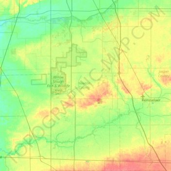
Nom : Carte topographique Newton County, altitude, relief.
Lieu : Newton County, Indiana, USA (40.73651 -87.52663 41.21867 -87.26641)
Altitude moyenne : 205 m
Altitude minimum : 187 m
Altitude maximum : 238 m
Autres cartes topographiques
Cliquez sur une carte pour visualiser sa topographie, son altitude et son relief.
Logansport
USA > Indiana > Logansport
Logansport, Cass County, Indiana, 46947, USA
Altitude moyenne : 203 m
Maple Lane
USA > Indiana > Maple Lane
Maple Lane, Saint Joseph County, Indiana, 46617:46635, USA
Altitude moyenne : 229 m
Eaglewood Estates
USA > Indiana > Eaglewood Estates
Eaglewood Estates, Boone County, Indiana, 46077, USA
Altitude moyenne : 279 m
Bloomfield
USA > Indiana > Bloomfield
Bloomfield, Greene County, Indiana, 47424, USA
Altitude moyenne : 168 m
Preservation Park
USA > Indiana > Jeffersonville
Preservation Park, 120, Jeffersonville, Clark County, Indiana, 47130, USA
Altitude moyenne : 136 m
Ontario Park
Ontario Park, Ontario, LaGrange County, Indiana, USA
Altitude moyenne : 269 m
Cherryvale
USA > Indiana > Cherryvale
Cherryvale, Vigo County, Indiana, 47878, USA
Altitude moyenne : 186 m
Anderson River
Anderson River, Spencer County, Indiana, 47588, USA
Altitude moyenne : 139 m
Little Cedar Lake
Little Cedar Lake, East Island Court, Tri-Lakes, Whitley County, Indiana, USA
Altitude moyenne : 284 m
Clarksville
USA > Indiana > Clarksville
Clarksville, Clark County, Indiana, 47129, USA
Altitude moyenne : 150 m
Holmesville
USA > Indiana > Holmesville
Holmesville, LaPorte County, Indiana, 46391, USA
Altitude moyenne : 240 m