
Carte topographique Westfalenpark
Carte interactive
Cliquez sur la carte pour afficher l’altitude.
À propos de cette carte
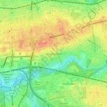
Nom : Carte topographique Westfalenpark, altitude, relief.
Altitude moyenne : 110 m
Altitude minimum : 83 m
Altitude maximum : 134 m
Autres cartes topographiques
Cliquez sur une carte pour visualiser sa topographie, son altitude et son relief.
Freibad Froschloch
Germany > North Rhine-Westphalia > Dortmund
Freibad Froschloch, 103, Löttringhauser Straße, Löttringhausen, Hombruch, Dortmund, North Rhine-Westphalia, 44225, Germany
Altitude moyenne : 111 m
Lütgendortmund-Ost
Germany > North Rhine-Westphalia > Dortmund
Lütgendortmund-Ost, Dortmund, North Rhine-Westphalia, Germany
Altitude moyenne : 96 m
Phoenix-See
Germany > North Rhine-Westphalia > Dortmund
Phoenix-See, Phoenixseestraße, Hörde, Dortmund, Regierungsbezirk Arnsberg, North Rhine-Westphalia, 44263, Germany
Altitude moyenne : 116 m