
Carte topographique Seeheim
Carte interactive
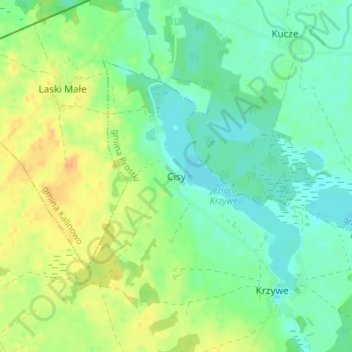
Cliquez sur la carte pour afficher l’altitude.
À propos de cette carte
Nom : Carte topographique Seeheim, altitude, relief.
Altitude moyenne : 128 m
Altitude minimum : 115 m
Altitude maximum : 146 m
Autres cartes topographiques
Cliquez sur une carte pour visualiser sa topographie, son altitude et son relief.
Auersberg
Polen > Woiwodschaft Ermland-Masuren > powiat ełcki
Auersberg, Gemeinde Dreimühlen, powiat ełcki, Woiwodschaft Ermland-Masuren, 19-311, Polen
Altitude moyenne : 168 m
Lyck
Polen > Woiwodschaft Ermland-Masuren > powiat ełcki > Lyck
Lyck, powiat ełcki, Woiwodschaft Ermland-Masuren, 19-300, Polen
Altitude moyenne : 129 m
Maschen
Polen > Woiwodschaft Ermland-Masuren > powiat ełcki
Maschen, Gemeinde Dreimühlen, powiat ełcki, Woiwodschaft Ermland-Masuren, 19-311, Polen
Altitude moyenne : 166 m