
Carte topographique Municipal Unit of Delphi
Carte interactive
Cliquez sur la carte pour afficher l’altitude.
À propos de cette carte
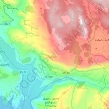
Nom : Carte topographique Municipal Unit of Delphi, altitude, relief.
Altitude moyenne : 693 m
Altitude minimum : -1 m
Altitude maximum : 1 645 m
Autres cartes topographiques
Cliquez sur une carte pour visualiser sa topographie, son altitude et son relief.
Mornos Artificial Lake
Greece > Thessaly and Central Greece > Regional Unit of Phocis > Municipal Unit of Vardousia
Mornos Artificial Lake, Municipal Unit of Vardousia, Dorida Municipality, Regional Unit of Phocis, Central Greece, Thessaly and Central Greece, Greece
Altitude moyenne : 672 m
Mornos
Greece > Thessaly and Central Greece > Regional Unit of Phocis > Municipal Unit of Efpalio
Mornos, Community of Trikorfo, Municipal Unit of Efpalio, Dorida Municipality, Regional Unit of Phocis, Central Greece, Thessaly and Central Greece, Greece
Altitude moyenne : 206 m
Dytiki Soufla
Greece > Thessaly and Central Greece > Regional Unit of Phocis > Municipal Unit of Vardousia
Dytiki Soufla, Municipal Unit of Vardousia, Dorida Municipality, Regional Unit of Phocis, Central Greece, Thessaly and Central Greece, Greece
Altitude moyenne : 1 893 m