
Carte topographique Annur
Carte interactive
Cliquez sur la carte pour afficher l’altitude.
À propos de cette carte
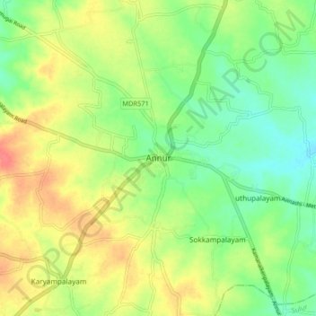
Nom : Carte topographique Annur, altitude, relief.
Altitude moyenne : 381 m
Altitude minimum : 356 m
Altitude maximum : 412 m
Annur is located at 11°14′N 77°08′E / 11.23°N 77.13°E / 11.23; 77.13.[4] It has an average elevation of 338 metres (1108 feet). Annur is well connected by roads including the National Highway 209 (New NH948) (Coimbatore to Bangalore highway) and the State Highway 80 SH80 Avanashi to Mettupalayam passes through Annur.
Autres cartes topographiques
Cliquez sur une carte pour visualiser sa topographie, son altitude et son relief.
Anaikatti
India > Tamil Nadu > Coimbatore North
Anaikatti, Mannarkad, Palakkad District, Kerala, 678741, India
Altitude moyenne : 623 m
Coimbatore
India > Tamil Nadu > Coimbatore North
Coimbatore, Coimbatore North, Coimbatore District, Tamil Nadu, 641001, India
Altitude moyenne : 452 m
Somayampalayam
India > Tamil Nadu > Coimbatore North
Somayampalayam, Coimbatore North, Coimbatore District, Tamil Nadu, 641041, India
Altitude moyenne : 471 m
Karyampalayam
India > Tamil Nadu > Coimbatore North
Karyampalayam, Coimbatore North, Coimbatore District, Tamil Nadu, 638653, India
Altitude moyenne : 390 m
Athipalayam
India > Tamil Nadu > Coimbatore North
Athipalayam, Coimbatore North, Coimbatore District, Tamil Nadu, 641020, India
Altitude moyenne : 414 m
Krishnampathi Lake
India > Tamil Nadu > Coimbatore North > Coimbatore
Krishnampathi Lake, Ward 20, West Zone, Coimbatore, Coimbatore North, Coimbatore District, Tamil Nadu, 641001, India
Altitude moyenne : 425 m
Sanganoor Stream
India > Tamil Nadu > Coimbatore North > Coimbatore
Sanganoor Stream, Ward 70, Central Zone, Coimbatore, Coimbatore North, Coimbatore District, Tamil Nadu, 641001, India
Altitude moyenne : 404 m
Chinnavedampatti
India > Tamil Nadu > Coimbatore North > Chinnavedampatti
Chinnavedampatti, Coimbatore North, Coimbatore District, Tamil Nadu, 641049, India
Altitude moyenne : 428 m
Ward 34
India > Tamil Nadu > Coimbatore North > Kalapatti
Ward 34, East Zone, Kalapatti, Coimbatore North, Coimbatore District, Tamil Nadu, India
Altitude moyenne : 396 m
Kovilpalayam
India > Tamil Nadu > Coimbatore North
Kovilpalayam, Coimbatore North, Coimbatore District, Tamil Nadu, 641107, India
Altitude moyenne : 391 m
KNG Pudur Pirivu
India > Tamil Nadu > Coimbatore North
KNG Pudur Pirivu, Coimbatore North, Coimbatore District, Tamil Nadu, 641025, India
Altitude moyenne : 462 m
Ward 54
India > Tamil Nadu > Coimbatore North
Ward 54, Central Zone, Coimbatore North, Coimbatore District, Tamil Nadu, 641009, India
Altitude moyenne : 424 m
Kalapatti
India > Tamil Nadu > Coimbatore North
Kalapatti, Coimbatore North, Coimbatore District, Tamil Nadu, 641048, India
Altitude moyenne : 402 m
Veerapandi Pirivu
India > Tamil Nadu > Coimbatore North
Veerapandi Pirivu, Coimbatore North, Coimbatore District, Tamil Nadu, 641047, India
Altitude moyenne : 417 m
Villangkurichi
India > Tamil Nadu > Coimbatore North
Villangkurichi, Coimbatore North, Coimbatore District, Tamil Nadu, 641035, India
Altitude moyenne : 414 m