Faire un don
Équipez-vous pour votre prochaine aventure :
En tant que Partenaire Amazon, ce site perçoit une commission sur les achats éligibles sans surcoût pour vous.
Carte topographique Keonjhar
Cliquez sur la carte pour afficher l’altitude.
Faire un don
Équipez-vous pour votre prochaine aventure :
En tant que Partenaire Amazon, ce site perçoit une commission sur les achats éligibles sans surcoût pour vous.
À propos de cette carte
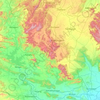
Nom : Carte topographique Keonjhar, altitude, relief.
Lieu : Keonjhar, Kendujhar, Odisha, 758018, India (20.80000 84.80000 22.20000 86.20000)
Altitude moyenne : 301 m
Altitude minimum : 12 m
Altitude maximum : 1 162 m
Faire un don
Équipez-vous pour votre prochaine aventure :
En tant que Partenaire Amazon, ce site perçoit une commission sur les achats éligibles sans surcoût pour vous.
Autres cartes topographiques
Cliquez sur une carte pour visualiser sa topographie, son altitude et son relief.
Faire un don
Équipez-vous pour votre prochaine aventure :
En tant que Partenaire Amazon, ce site perçoit une commission sur les achats éligibles sans surcoût pour vous.
Faire un don
Équipez-vous pour votre prochaine aventure :
En tant que Partenaire Amazon, ce site perçoit une commission sur les achats éligibles sans surcoût pour vous.
Mayurbhanj
Mayurbhanj's geography is defined by the Simlipal National Park located in the centre of the district. Covering more than a fourth of the district's area, these forests surround the Simlipal Hills, which form the watershed for the district dividing the district into distinct east and west regions. Elevations…
Altitude moyenne : 239 m
Abdul Kalam Island
In May 2013, increasing concern has been drawn to the change of the island's topography, owing to sand erosion. Since the island is technically a shoal, seawater frequently causes sand-shifting. The DRDO sought the assistance of geological experts from National Institute of Ocean Technology to monitor the…
Altitude moyenne : 1 m
Faire un don
Équipez-vous pour votre prochaine aventure :
En tant que Partenaire Amazon, ce site perçoit une commission sur les achats éligibles sans surcoût pour vous.
Faire un don
Équipez-vous pour votre prochaine aventure :
En tant que Partenaire Amazon, ce site perçoit une commission sur les achats éligibles sans surcoût pour vous.
Faire un don
Équipez-vous pour votre prochaine aventure :
En tant que Partenaire Amazon, ce site perçoit une commission sur les achats éligibles sans surcoût pour vous.
Rayagada
The district's tribal population is 57.52 percent of the total. Its 11 blocks have been covered by a tribal sub-plan, with three micro-projects in operation for pre-literate indigenous tribal communities. Rayagada's topography helps the tribal communities maintain their cultural identity; 4,785.36 square…
Altitude moyenne : 522 m
Faire un don
Équipez-vous pour votre prochaine aventure :
En tant que Partenaire Amazon, ce site perçoit une commission sur les achats éligibles sans surcoût pour vous.
Angul
Angul is located in the centre of the state of Odisha and lies between the latitudes of 20°31′N and 21°40′N and longitudes of 84°15′E and 85°23′E. The altitude is between 564 and 1,187 metres (1,850 and 3,894 ft). The district has an area of 6,232 km2 (2,406 sq mi). It is bounded by Dhenkanal and…
Altitude moyenne : 234 m
Faire un don
Équipez-vous pour votre prochaine aventure :
En tant que Partenaire Amazon, ce site perçoit une commission sur les achats éligibles sans surcoût pour vous.
Gajapati
The Mahendratanaya River, a tributary of the Banshadhara River, is the primary river flowing through the district. The highest peak in the district is Mahendragiri, standing at 1,501 meters (4,925 feet), followed by Dandamera Parbat at 1,103 meters (3,619 feet) and Tangiri Parbat at 1,155 meters (3,789 feet).…
Altitude moyenne : 341 m
Jagatsinghapur
Jagatsinghpur is situated on an elevation of 15 meters (49 feet). It is the smallest district in the state and covers a landmass of 1759 km2. The place lies between 8603' to 86045' East Longitude and between 19058' to 20023' North latitude. It is predominantly recognized due to its triangular geographical…
Altitude moyenne : 6 m
Faire un don
Équipez-vous pour votre prochaine aventure :
En tant que Partenaire Amazon, ce site perçoit une commission sur les achats éligibles sans surcoût pour vous.
Faire un don
Équipez-vous pour votre prochaine aventure :
En tant que Partenaire Amazon, ce site perçoit une commission sur les achats éligibles sans surcoût pour vous.
Faire un don
Équipez-vous pour votre prochaine aventure :
En tant que Partenaire Amazon, ce site perçoit une commission sur les achats éligibles sans surcoût pour vous.
Mayurbhanj
Mayurbhanj's geography is defined by the Simlipal National Park located in the centre of the district. Covering more than a fourth of the district's area, these forests surround the Simlipal Hills, which form the watershed for the district dividing the district into distinct east and west regions. Elevations…
Altitude moyenne : 239 m
Faire un don
Équipez-vous pour votre prochaine aventure :
En tant que Partenaire Amazon, ce site perçoit une commission sur les achats éligibles sans surcoût pour vous.
Faire un don
Équipez-vous pour votre prochaine aventure :
En tant que Partenaire Amazon, ce site perçoit une commission sur les achats éligibles sans surcoût pour vous.
Faire un don
Équipez-vous pour votre prochaine aventure :
En tant que Partenaire Amazon, ce site perçoit une commission sur les achats éligibles sans surcoût pour vous.
Faire un don
Équipez-vous pour votre prochaine aventure :
En tant que Partenaire Amazon, ce site perçoit une commission sur les achats éligibles sans surcoût pour vous.
Faire un don
Équipez-vous pour votre prochaine aventure :
En tant que Partenaire Amazon, ce site perçoit une commission sur les achats éligibles sans surcoût pour vous.
Baripada
India > Odisha > Baripada (M)
Baripada is at 21°56′N 86°43′E / 21.94°N 86.72°E / 21.94; 86.72. It has an average elevation of 36 metres (118 feet). The city lies along the Budhabalanga River.
Altitude moyenne : 41 m
Faire un don
Équipez-vous pour votre prochaine aventure :
En tant que Partenaire Amazon, ce site perçoit une commission sur les achats éligibles sans surcoût pour vous.
Faire un don
Équipez-vous pour votre prochaine aventure :
En tant que Partenaire Amazon, ce site perçoit une commission sur les achats éligibles sans surcoût pour vous.
Faire un don
Équipez-vous pour votre prochaine aventure :
En tant que Partenaire Amazon, ce site perçoit une commission sur les achats éligibles sans surcoût pour vous.
Faire un don
Équipez-vous pour votre prochaine aventure :
En tant que Partenaire Amazon, ce site perçoit une commission sur les achats éligibles sans surcoût pour vous.
Faire un don
Équipez-vous pour votre prochaine aventure :
En tant que Partenaire Amazon, ce site perçoit une commission sur les achats éligibles sans surcoût pour vous.
Faire un don
Équipez-vous pour votre prochaine aventure :
En tant que Partenaire Amazon, ce site perçoit une commission sur les achats éligibles sans surcoût pour vous.
Faire un don
Équipez-vous pour votre prochaine aventure :
En tant que Partenaire Amazon, ce site perçoit une commission sur les achats éligibles sans surcoût pour vous.
Faire un don
Équipez-vous pour votre prochaine aventure :
En tant que Partenaire Amazon, ce site perçoit une commission sur les achats éligibles sans surcoût pour vous.
Angul
Angul is located in the centre of the state of Odisha and lies between the latitudes of 20°31′N and 21°40′N and longitudes of 84°15′E and 85°23′E. The altitude is between 564 and 1,187 metres (1,850 and 3,894 ft). The district has an area of 6,232 km2 (2,406 sq mi). It is bounded by Dhenkanal and…
Altitude moyenne : 234 m
Netaji Subash chandra Bose Park
India > Odisha > Bhubaneswar (M.Corp.) > Bhubaneswar Municipal Corporation
Altitude moyenne : 34 m
Faire un don
Équipez-vous pour votre prochaine aventure :
En tant que Partenaire Amazon, ce site perçoit une commission sur les achats éligibles sans surcoût pour vous.
Faire un don
Équipez-vous pour votre prochaine aventure :
En tant que Partenaire Amazon, ce site perçoit une commission sur les achats éligibles sans surcoût pour vous.
