
Carte topographique Youyu County
Carte interactive
Cliquez sur la carte pour afficher l’altitude.
À propos de cette carte
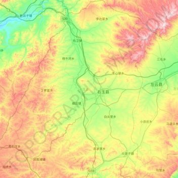
Nom : Carte topographique Youyu County, altitude, relief.
Lieu : Youyu County, Shuozhou City, Shanxi, China (39.69259 112.11211 40.29863 112.64180)
Altitude moyenne : 1 486 m
Altitude minimum : 1 130 m
Altitude maximum : 2 058 m
Elevations are generally higher in the south of the county, in which flows the Cangtou River (苍头河); Youyu reaches a north-south extent of 67.7 km (42.1 mi) and east-west width of 45.7 km (28.4 mi). The Great Wall demarcates the northwestern border with Inner Mongolia's Liangcheng and Horinger counties; within the province, Youyu borders Zuoyun County to the east, Shanyin County and Pinglu District to the south.
Autres cartes topographiques
Cliquez sur une carte pour visualiser sa topographie, son altitude et son relief.
Pingyao County
China > Shanxi > Jinzhong City
Pingyao County, Jinzhong City, Shanxi, 031100, China
Altitude moyenne : 1 128 m
Hejin
China > Shanxi > Hejin City > Chengqu Subdistrict
Hejin, Chengqu Subdistrict, Hejin City, Yuncheng City, Shanxi, 043300, China
Altitude moyenne : 529 m
Linyi
China > Shanxi > Linyi County
Linyi, Linyi County, Yuncheng City, Shanxi, China
Altitude moyenne : 455 m
Shiba
China > Shanxi > Ningwu County > Shiba
Shiba, Ningwu County, Xinzhou City, Shanxi, China
Altitude moyenne : 1 599 m
Pingcheng District
China > Shanxi > Pingcheng District
Datong, Pingcheng District, Datong City, Shanxi, 037004, China
Altitude moyenne : 1 149 m
Gulou Subdistrict
China > Shanxi > Gulou Subdistrict
Gulou Subdistrict, Huozhou City, Linfen Shi, Shanxi, China
Altitude moyenne : 560 m
Yuncheng
China > Shanxi > Dongcheng Subdistrict
Yuncheng, Dongcheng Subdistrict, Yanhu District, Yuncheng City, Shanxi, 044031, China
Altitude moyenne : 478 m