
Faire un don
Équipez-vous pour votre prochaine aventure :
En tant que Partenaire Amazon, ce site perçoit une commission sur les achats éligibles sans surcoût pour vous.
Carte topographique Muktinath
Cliquez sur la carte pour afficher l’altitude.
Faire un don
Équipez-vous pour votre prochaine aventure :
En tant que Partenaire Amazon, ce site perçoit une commission sur les achats éligibles sans surcoût pour vous.
Muktinath
Muktinath is a Vishnu temple, sacred to both Hindus and Buddhists. It is located in Muktinath Valley at the foot of the Thorong La mountain pass in Mustang, Nepal. It is one of the world's highest temples (altitude 3,800 m). Within Hinduism, it is one of the 108 Divya Desams, and is the only Divya Desam located outside India. It known as Mukti Kshetra, which literally means the 'liberation arena' (moksh) and is one of the Char Dham in Nepal.[1]
Faire un don
Équipez-vous pour votre prochaine aventure :
En tant que Partenaire Amazon, ce site perçoit une commission sur les achats éligibles sans surcoût pour vous.
À propos de cette carte
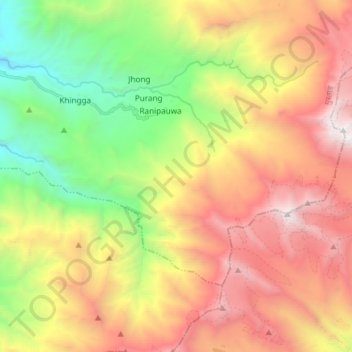
Nom : Carte topographique Muktinath, altitude, relief.
Altitude moyenne : 4 668 m
Altitude minimum : 3 001 m
Altitude maximum : 6 475 m
Faire un don
Équipez-vous pour votre prochaine aventure :
En tant que Partenaire Amazon, ce site perçoit une commission sur les achats éligibles sans surcoût pour vous.
Autres cartes topographiques
Cliquez sur une carte pour visualiser sa topographie, son altitude et son relief.