
Carte topographique Municipality of Marousi
Carte interactive
Cliquez sur la carte pour afficher l’altitude.
À propos de cette carte
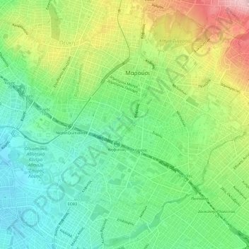
Nom : Carte topographique Municipality of Marousi, altitude, relief.
Altitude moyenne : 224 m
Altitude minimum : 149 m
Altitude maximum : 355 m
Autres cartes topographiques
Cliquez sur une carte pour visualiser sa topographie, son altitude et son relief.
Municipal Unit of Neo Psychiko
Greece > Attica > Regional Unit of North Athens
Municipal Unit of Neo Psychiko, Municipality of Filothei - Psychiko, Regional Unit of North Athens, Attica, 154 51, Greece
Altitude moyenne : 191 m
Chalandri
Greece > Attica > Regional Unit of North Athens
Chalandri, Municipality of Chalandri, Regional Unit of North Athens, Attica, 152 32, Greece
Altitude moyenne : 222 m
Marousi
Greece > Attica > Regional Unit of North Athens
Marousi, Municipality of Marousi, Regional Unit of North Athens, Attica, 151 24, Greece
Altitude moyenne : 257 m
Penteli Municipal Unit
Greece > Attica > Regional Unit of North Athens
Penteli Municipal Unit, Municipality of Penteli, Regional Unit of North Athens, Attica, 152 36, Greece
Altitude moyenne : 422 m
Olympus
Greece > Attica > Regional Unit of North Athens > Municipal Unit of Psychiko
Olympus, Municipal Unit of Psychiko, Municipality of Filothei - Psychiko, Regional Unit of North Athens, Attica, 154 52, Greece
Altitude moyenne : 204 m
Municipality of Metamorfosi
Greece > Attica > Regional Unit of North Athens
Municipality of Metamorfosi, Regional Unit of North Athens, Attica, Greece
Altitude moyenne : 174 m
Nea Penteli Municipal Unit
Greece > Attica > Regional Unit of North Athens > Nea Penteli Municipal Unit
Nea Penteli Municipal Unit, Municipality of Penteli, Regional Unit of North Athens, Attica, Greece
Altitude moyenne : 496 m
Municipality of Chalandri
Greece > Attica > Regional Unit of North Athens > Municipality of Chalandri
Municipality of Chalandri, Regional Unit of North Athens, Attica, Greece
Altitude moyenne : 208 m
Municipality of Kifisia
Greece > Attica > Regional Unit of North Athens
Municipality of Kifisia, Regional Unit of North Athens, Attica, Greece
Altitude moyenne : 342 m