
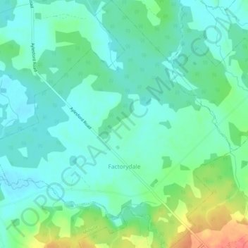
Carte topographique Factorydale
Carte interactive
Cliquez sur la carte pour afficher l’altitude.
À propos de cette carte
Nom : Carte topographique Factorydale, altitude, relief.
Altitude moyenne : 43 m
Altitude minimum : 26 m
Altitude maximum : 91 m
Autres cartes topographiques
Cliquez sur une carte pour visualiser sa topographie, son altitude et son relief.
Harmony
Canada > Nova Scotia > Municipality of the County of Kings
Harmony, Municipality of the County of Kings, Kings County, Nova Scotia, B0P 1R0, Canada
Altitude moyenne : 129 m
Aylesford
Canada > Nova Scotia > Municipality of the County of Kings
Aylesford, Municipality of the County of Kings, Kings County, Nova Scotia, B0P 1C0, Canada
Altitude moyenne : 30 m
Tremont
Canada > Nova Scotia > Municipality of the County of Kings
Tremont, Municipality of the County of Kings, Kings County, Nova Scotia, B0P 1R0, Canada
Altitude moyenne : 58 m
Bishopville
Canada > Nova Scotia > Municipality of the County of Kings
Bishopville, Municipality of the County of Kings, Kings County, Nova Scotia, B0P 1P0, Canada
Altitude moyenne : 88 m
Greenwich
Canada > Nova Scotia > Municipality of the County of Kings
Greenwich, Municipality of the County of Kings, Kings County, Nova Scotia, B4P 0B2, Canada
Altitude moyenne : 32 m
Kingston
Canada > Nova Scotia > Municipality of the County of Kings
Kingston, Municipality of the County of Kings, Kings County, Nova Scotia, B0P 1R0, Canada
Altitude moyenne : 30 m
Steam Mill
Canada > Nova Scotia > Municipality of the County of Kings
Steam Mill, Municipality of the County of Kings, Kings County, Nova Scotia, Canada
Altitude moyenne : 22 m
East Margaretsville
Canada > Nova Scotia > Municipality of the County of Kings
East Margaretsville, Municipality of the County of Kings, Kings County, Nova Scotia, B0P 1R0, Canada
Altitude moyenne : 91 m
Lumsden Pond
Canada > Nova Scotia > Municipality of the County of Kings > Lumsden Dam
Lumsden Pond, Lumsden Dam, Municipality of the County of Kings, Kings County, Nova Scotia, Canada
Altitude moyenne : 170 m
Armstrong Lake
Canada > Nova Scotia > Municipality of the County of Kings
Armstrong Lake, Municipality of the County of Kings, Kings County, Nova Scotia, Canada
Altitude moyenne : 208 m
Hortonville
Canada > Nova Scotia > Municipality of the County of Kings
Hortonville, Municipality of the County of Kings, Kings County, Nova Scotia, Canada
Altitude moyenne : 16 m
Salmontail Lake
Canada > Nova Scotia > Municipality of the County of Kings
Salmontail Lake, Municipality of the County of Kings, Kings County, Nova Scotia, Canada
Altitude moyenne : 226 m
Blue Mountain
Canada > Nova Scotia > Municipality of the County of Kings
Blue Mountain, Municipality of the County of Kings, Kings County, Nova Scotia, B4N 3V8, Canada
Altitude moyenne : 224 m
Greenwood
Canada > Nova Scotia > Municipality of the County of Kings
Greenwood, Municipality of the County of Kings, Kings County, Nova Scotia, B0P 1N0, Canada
Altitude moyenne : 28 m
Grand Pre
Canada > Nova Scotia > Municipality of the County of Kings
Grand Pre, Municipality of the County of Kings, Kings County, Nova Scotia, B0P 1M0, Canada
Altitude moyenne : 21 m
North Kingston
Canada > Nova Scotia > Municipality of the County of Kings
North Kingston, Municipality of the County of Kings, Kings County, Nova Scotia, B0P 1R0, Canada
Altitude moyenne : 88 m
Bishopville
Canada > Nova Scotia > Municipality of the County of Kings
Bishopville, Municipality of the County of Kings, Kings County, Nova Scotia, B0P 1P0, Canada
Altitude moyenne : 81 m
Kingsport
Canada > Nova Scotia > Municipality of the County of Kings
Kingsport, Municipality of the County of Kings, Kings County, Nova Scotia, B0P 1T0, Canada
Altitude moyenne : 9 m
Halls Harbour
Canada > Nova Scotia > Municipality of the County of Kings
Halls Harbour, Municipality of the County of Kings, Kings County, Nova Scotia, Canada
Altitude moyenne : 79 m
Frog Lake
Canada > Nova Scotia > Municipality of the County of Kings
Frog Lake, Municipality of the County of Kings, Kings County, Nova Scotia, Canada
Altitude moyenne : 211 m
Gaspereau
Canada > Nova Scotia > Municipality of the County of Kings
Gaspereau, Municipality of the County of Kings, Kings County, Nova Scotia, B4P 2R1, Canada
Altitude moyenne : 113 m