
Carte topographique Mount Vernon
Carte interactive
Cliquez sur la carte pour afficher l’altitude.
À propos de cette carte
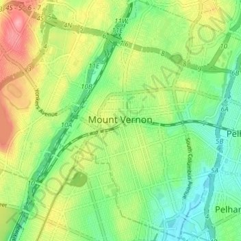
Nom : Carte topographique Mount Vernon, altitude, relief.
Lieu : Mount Vernon, Westchester County, New York, United States (40.88982 -73.85347 40.93532 -73.80502)
Altitude moyenne : 41 m
Altitude minimum : 0 m
Altitude maximum : 106 m
Mount Vernon's elevation at City Hall is about 235 feet (72 m), reflecting its location between the Bronx River to the west and the Hutchinson River to the east. On a clear day, the Throgs Neck Bridge can be seen from 10 miles (20 km) away from many parts of the city, while at night, the bridge's lights can also be seen. The city's seal, created in 1892, depicts what were then considered the highest points in Mount Vernon: Trinity Place near Fourth Street, Vista Place at Barnes Avenue, and North 10th Street between Washington and Jefferson places. Since then, it was discovered that the city's highest elevation is on New York Route 22, North Columbus Avenue, at the Bronxville line.
Autres cartes topographiques
Cliquez sur une carte pour visualiser sa topographie, son altitude et son relief.
West Mount Vernon
United States > New York > Westchester County > Mount Vernon > West Mount Vernon
West Mount Vernon, Mount Vernon, Westchester County, New York, 10550, United States
Altitude moyenne : 49 m