
Carte topographique Jayapura
Carte interactive
Cliquez sur la carte pour afficher l’altitude.
À propos de cette carte
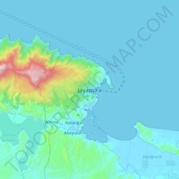
Nom : Carte topographique Jayapura, altitude, relief.
Lieu : Jayapura, Papua, 99111, Indonesia (-2.69875 140.54374 -2.37875 140.86374)
Altitude moyenne : 149 m
Altitude minimum : 0 m
Altitude maximum : 1 660 m
The topography of Jayapura varies from valleys to hills, plateaus, and mountains up to 700 metres (2,300 ft) above sea level. Jayapura overlooks the Yos Sudarso Bay. Jayapura is about 94,000 hectares (230,000 acres) in area, and is divided into five districts. Around 30% of the area is inhabited, with the remainder consisting of a rough terrain, swamps, and protected forest. The average temperature is 29–31.8 °C (84.2–89.2 °F).