
Faire un don
Équipez-vous pour votre prochaine aventure :
En tant que Partenaire Amazon, ce site perçoit une commission sur les achats éligibles sans surcoût pour vous.
Carte topographique Izena
Cliquez sur la carte pour afficher l’altitude.
Faire un don
Équipez-vous pour votre prochaine aventure :
En tant que Partenaire Amazon, ce site perçoit une commission sur les achats éligibles sans surcoût pour vous.
Izena
The island's topography features a row of mountains spanning from the northwest to the southeast of the island, with generally flat, arable land covering the remainder. The island has several sandy beaches and designated camping areas with bathroom facilities. The view of Izena's rocky southern coastline is well known as one of Japan's best, with the rock formations 'Umi Gitara' and 'Agi Gitara' dramatically rising from the land and sea.
Faire un don
Équipez-vous pour votre prochaine aventure :
En tant que Partenaire Amazon, ce site perçoit une commission sur les achats éligibles sans surcoût pour vous.
À propos de cette carte
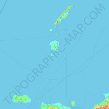
Nom : Carte topographique Izena, altitude, relief.
Lieu : Izena, Shimajiri, Okinawa Prefecture, Japan (26.79814 127.64823 26.99760 128.13152)
Altitude moyenne : 3 m
Altitude minimum : 0 m
Altitude maximum : 335 m
Faire un don
Équipez-vous pour votre prochaine aventure :
En tant que Partenaire Amazon, ce site perçoit une commission sur les achats éligibles sans surcoût pour vous.
Autres cartes topographiques
Cliquez sur une carte pour visualiser sa topographie, son altitude et son relief.