
Carte topographique Puerto Rico
Carte interactive
Cliquez sur la carte pour afficher l’altitude.
À propos de cette carte
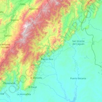
Nom : Carte topographique Puerto Rico, altitude, relief.
Lieu : Puerto Rico, Caquetá, Amazonia, Colombia (1.38758 -75.34858 2.62838 -74.78266)
Altitude moyenne : 846 m
Altitude minimum : 207 m
Altitude maximum : 3 444 m
The island is mostly mountainous with large coastal areas in the north and south. The main mountain range is called "La Cordillera Central" (The Central Range). The highest elevation in Puerto Rico, Cerro de Punta 4,390 feet (1,340 m), is located in this range.
Autres cartes topographiques
Cliquez sur une carte pour visualiser sa topographie, son altitude et son relief.
Cartagena del Chairá
Cartagena del Chairá, Caquetá, RAP Amazonía, Colombia
Altitude moyenne : 240 m
Chiribiquete (Macizo Central)
Chiribiquete (Macizo Central), Solano, Caquetá, Colombia
Altitude moyenne : 290 m
Azabache
Colombia > Caquetá > Belén de los Andaquíes
Azabache, Belén de los Andaquíes, Caquetá, Colombia
Altitude moyenne : 253 m
San Vicente del Caguán
San Vicente del Caguán, Caquetá, 182010, Colombia
Altitude moyenne : 585 m
Puerto Gaitan
Colombia > Caquetá > Puerto Gaitan
Puerto Gaitan, La Montañita, Caquetá, Colombia
Altitude moyenne : 249 m
San Vicente del Caguán
Colombia > Caquetá > San Vicente del Caguán > San Vicente del Caguán
San Vicente del Caguán, Caquetá, 182010, Colombia
Altitude moyenne : 276 m