
Carte topographique Hohenau
Carte interactive
Cliquez sur la carte pour afficher l’altitude.
À propos de cette carte
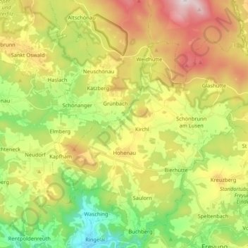
Nom : Carte topographique Hohenau, altitude, relief.
Lieu : Hohenau, Landkreis Freyung-Grafenau, Bavaria, 94545, Germany (48.80931 13.44401 48.91500 13.57674)
Altitude moyenne : 729 m
Altitude minimum : 401 m
Altitude maximum : 1 169 m
Autres cartes topographiques
Cliquez sur une carte pour visualiser sa topographie, son altitude et son relief.
Bierhütte
Germany > Bavaria > Landkreis Freyung-Grafenau
Bierhütte, Hohenau, Landkreis Freyung-Grafenau, Bavaria, 94545, Germany
Altitude moyenne : 716 m
Waldkirchen
Germany > Bavaria > Landkreis Freyung-Grafenau
Waldkirchen, Landkreis Freyung-Grafenau, Bavaria, 94065, Germany
Altitude moyenne : 599 m
Zenting
Germany > Bavaria > Landkreis Freyung-Grafenau > Zenting
Zenting, Thurmansbang (VGem), Landkreis Freyung-Grafenau, Bavaria, 94579, Germany
Altitude moyenne : 550 m
Freyung
Germany > Bavaria > Landkreis Freyung-Grafenau > Freyung
Freyung, Landkreis Freyung-Grafenau, Bavaria, 94078, Germany
Altitude moyenne : 695 m