
Carte topographique Southern Crater Lake
Carte interactive
Cliquez sur la carte pour afficher l’altitude.
À propos de cette carte
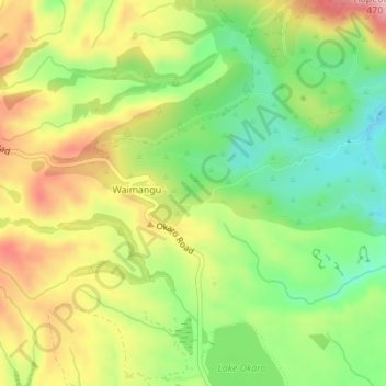
Nom : Carte topographique Southern Crater Lake, altitude, relief.
Altitude moyenne : 429 m
Altitude minimum : 344 m
Altitude maximum : 531 m
Autres cartes topographiques
Cliquez sur une carte pour visualiser sa topographie, son altitude et son relief.
Inferno Crater Lake
New Zealand > Bay of Plenty > Waimangu
Inferno Crater Lake, Mt Haszard Hiking Trail, Waimangu, Rotorua District, Bay of Plenty, New Zealand
Altitude moyenne : 421 m